City Residents Will Have Final Say On River Road Dike
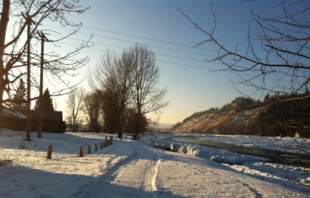
The walking trail and fish hatchery alongside the Nechako would lie within the floodway, with the proposed dike right beside River Road
Prince George, BC – City Councillors have voted in favour of moving forward with an $11.5-million dollar dike project that would mitigate the flood risk along River Road, but, in the end, the final decision lies with Prince George voters.
At last night’s meeting, Councillors voted 6-1 in favour of accepting a $5.4-million dollar federal/provincial grant towards the project. Another $2.5-million will come from the City’s Land Development Reserve fund. And Council will decide at its February 20th meeting whether to hold a referendum or employ the Alternate Approval Process to seek public support to borrow the remaining $3.6-million dollars (click here for previous story)
If approved, the project would see 3.3-kilometres of flood protection dike built on the north side of River Road, immediately adjacent to the road. The City’s Manager of Utilities, Dave Dyer says, "As an offset dike, rather than a river-side dike, the project will allow flood waters room to flood over lands within the floodway of the Nechako River during flood events, provide for more predictable construction costs, minimize annual maintenance and repair costs and reduce the impact on the riparian area of the Nechako River."
Dyer says a subdrain and pump chamber system were installed in 2009 and this dike project also includes a 1.7-kilometre groundwater cut-off wall that will work in conjunction with that drainage system to reduce the impact of groundwater flooding during flood events.
"The area that would be protected behind this dike would be a significant part of the industrial area along River Road, as well as the CN Rail tracks and yard – an important facility – as well as Highway 16 and a good part of the downtown towards the east-end of downtown." says Dyer. In explaining the rationale for the project to Councillors, he says, "It’s a fairly significant amount of land – I think close to 300-hectares – and because of the benefit for both a winter time or spring time freshet event, it’s one of the best uses of our…strategies for full protection for a significant economic part of the city."
Comments
Will this really help? My sense is that ground water seepage is the main issue and not a “blowout” type event where the river actually spills its banks and runs into the CN yards and across 1st Ave. Heck, has that latter scenario ever even happened?
Yup! Huge waste of money! When the water level increases to the height of the dike it will be the same height on the other side. It sure would be nice if our council would listen to someone other then the companies that are trying to sell them something.
Im betting that they go to the Alternate Approval Process. That way they are pretty well gauranteed that they will get their way. An APP is not by any stretch of the imagination giving Citizens the final say.
The City is infested with **Grant Money Junkies** and they seem unable to turn down any grants. As a result we end up with all kinds of projects that we dont need, or which could be done differently. We need a change on how money is given to Citys. We need to stop taking money with strings attached.
By all means lets protect CN with taxpayers money. The AAP is like a rigged election. The odds of winning are so stacked against the opponents that they may as well not have it. I say lets have a referendum on whether or not to scrap the AAP process. Wasnt there something in greens platform about getting rid of the AAP if people didnt want it?
The best way to get rid of the AAP is to win a couple is issues like this dike project, and the Performing Arts Centre.
If we could force these issues to a referendum and give taxpayers a vote on these issues they might be less inclined to use the process.
One has to remember that all the AAP does, is if you get the required 5000 signatures, you then get a referendum. At least getting it to the referendum stage, gives us some say in these matters.
I doubt if the present council has the gonads to go directly to referendum on this issue or on the PAC. They use the cost of the referendum as the reason for using the AAP process, but in fact, its not the cost, its the fear of losing, and then not being able to build their pet projects.
How long will we take this BS.
Dredge!
If an AAP win only gets us to the referendum stage, how can they use the cost of a referendum as an excuse not to use it, when we would be incurring double costs using the AAP if it then goes to a referendum. Typical bureaucratic reasoning.
I agree with Councillor Skakun who doesn’t want this project to go through. That amount of money could be nicely spent elsewhere. If I get a say, it will definitely be no. That’s too much money for such a small section of land.
at least Brian has some common sense and knows we can’t afford this. Brian, you’ve got my vote for Mayor!
But Brian is enjoying his raise that he voted against.. But did make him look good in the voters eyes.
Will we be looking at some sort of polling station or a mail out for voting? Would appreciate some ample time in order to place my vote.
I think city council has absolutely NO business applying an AAP for anything. It is very deceptive.
A “ground water cut off wall” Pardon?
How far below grade will they go to prevent ground water from seeping steadily southward (in their dirty underwear)
Sorry, that old song from Tennessee just sort of popped into my brain.
Someone here stated that the gravel bed is 60′ deep, it would not surprise me if was more than that. How can you build a wall to keep all or even some of the ground water on one side?
Man plans, God laughs.
metalman.
But if the mayority of council would have voted NO to the raise there would have been no raise and they ALL would have looked better!
========================================
Today’s paper states that city staff would require an additional 60 to 90 hours annually of staff time do have the same disclosure as Quesnel! Well, I don’t think that staff is paid by the HOUR! 60 to 90 hours per year boils down to one person devoting an hour and half or two hours per
WEEK doing this work! That’s 15 to 20 minutes per day Monday to Friday!
That is impossible? I don’t believe it.
Again, Councillor Brian Skakun, congratulations! Three years from now please run for mayor!
It is easy and safe to vote the popular way when you know it means nothing except it looks good to the voters. At what point in the vote did Skakun vote no? Was he the first, second, etc. Or do they all vote and toss it into a hat and pull them out one by one. I don’t think counsel holds secret ballots, so I am pretty sure each councillor knows which way the wind is blowing at the time they vote. The reason I say this is that Skakun always votes the popular way when he seems to be the only dissenting vote. Is this a political ploy to garner favour with the voting public? Has he ever been a deciding factor in a vote?
“…that Skakun always votes the popular way when he seems to be the only dissenting vote.” If the *popular* way is the *people’s* way I am all for it, because I am one of the people! And, of course, how can it be Brian’s fault to be the only dissenting vote? Remember, the one who said that the emperor has no clothes was the only dissenter too!
Talking about councillors who sit on the fence (asking to hear all the others first!) Brian is not one of them. Don’t want to mention names, if you have been watching city council meetings for the last few years you know who they are.
I will repeat again that the study commissioned by the City states on page iv that gravel extraction can be effective to lower flood levels in some rivers.
However, in this case they explored it and in the case of the Nechako it will not work.
The gravel bars that are clearly visible do not affect the open-water profiles when Fraser water levels are low (late fall and winter).
Specifically it states that removing gravel would increase flow area which then reduces velocities. Reduced velocities encourages more ice to accumulate.
The reason why gravel accumulates where it does in any river is due to low flow velocities.
In fact, they modelled removals of up to 2 million cubic metres. That did not provide any benefit.
What can be beneficial, in the case of ice, is enlarging existing side channels on both sides of the river as long as they remain ice free. In fact, the Cottonwood island side channel provided relief in the winter 2007/08 event and enlarging it to carry more flow would be beneficial.
Appendix G deals with the groundwater issue. As with any natural patterns, the subsurface material is not homogeneous. The percolation rates are variable depending on the locations. Test wells were placed and groundwater height was monitored in 2007/2008.
The report states that the proposed subdrain scheme is feasible and will have a beneficial effect on groundwater levels but will not extend the entire 600m width of the 2007/08 problem area.
– The effectiveness of the system will be enhanced by extending the cutoff to at least a 10m depth.
– The system does not have to extend the entire length of River Rd.
– Further site investigation is required to design the system in detail.
From my point of view, that part is the weakest part of the report.
It is difficult to determine what is underground. Sampling techniques were used which typically can miss key changes in subsurface conditions. There was no groundwater profile provided with the report, which I fear may be an indicator of the lack of solid information of a key component of the dike system design which has to include both the above ground and underground cutoff component.
You don’t have a clue about subsurface hydrology, do you metalman?
http://www.groundwaterimaging.com.au
Percolation rates of soils underground vary as much as they do near the surface.
http://www.geomodel.com/gw
I would like to see such a 3d model along the mouth of the Nechako from the Cameron St. Bridge east. I am conerned that they do not have enough information to do an actual visual model in the same fashion that they have a river model.
If they do not have enough info to model underground water, I fear the degree of certainty of how effective a cutoff structure will be very low.
So tell me what people would do if they were on Council or soem other decision making body and they commissioned a report to get some “expert” advice and that report stated that if certain action would be taken that the level and incidents of an undesirable event would be reduced. In fact, the reduced events would save people’s stress and save everyone money.
In many cases decision makers would be sued for lack of due diligence. If lives were lost, it would be even worse.
“City Residents Will Have Final Say On River Road Dike”
I do not believe that. Who thought up that headline?
It would be true if there was a question posed that asks whether people are in favour or against the dike. I do not think that is the question which will be posed, however.
That being said, should the residents be asked a qustion on public liability matters, or is that something we voted people into office to decide on?
This is not some public building. This is a structure intended to protect the City against public liability and protect those who live and work in the flood potential area and can stand to lose investments they made there.
Interestingly enough, when road improvements and other service improvements are made, the property owners directly affecteed by those improvements have to pay and their assessed property values will likely go up as will likely the values for purposes of property sales.
I would think that is the case here as well.
As someone wrote, CN ought to pay a portion, if their yards will be better protected.
Gus blurts out:
“You don’t have a clue about subsurface hydrology, do you metalman?”
Naw, I don’t have a clue about a lot of things Gus, including subsurface geology.
Just running with the assumption that the ancient river bed south of the current path of the Nechako is composed mainly of gravel, to an unknown depth below grade. It is only natural that some areas will not be composed of gravel, but of some more dense soil that will tend to impede the flow of subsurface water. All the poor layman can do is speculate based on having seen water mysteriously appear at certain times of the year on the ground, hundreds, even thousands of feet from either of our two rivers, and not a rain cloud in site!!
How ever, I bow to your superiority, Sir.
metalman.
I am not an engineer nor a hydrologist but hear is a thought I had. Do some minor dredging to remove any accumulated debris and then consider the thought of aeration. I have seen this done around docks on lakes to keep them ice free.
OK I am ready to be blown out of the water for this…:-)
Gus, I thought the City protected itself from public liability by posting warnings about the river, like they just did when the ice was clogging up the Nechako.
You know, when people buy buildings (houses, shops, etc.), they generally know what they are getting into. They make a decision based on those facts and so they should have to live with their decision. You cannot tell me that none of those businesses and the few houses down there on River Road didn’t know what they were getting into. I don’t see why we should spend this amount of money on this project at this time.
Dredge!
Gus. How much public liability does the City have for River Flooding. Or better still what is their responsibility for rivers.
Fact of the matter is this is a Provincial and Federal responsibility insofar as flooding goes. One of the reasons they are not into the dredging part of the operation is that they would have to get authority from DFO to dredge the rivers.
The concern about liabitilty is a huge cop out that is used on a consistant basis by Municipalties, because it allows them to do the things they want to do, with the threat of repercussions if they dont do it.
Where was the City’s reponsiblity in the past 60 years insofar as flooding goes.???
To reverse your comment. What is the Citys responsibility if they put up this dike based on the information received from the Engineers, and the dyke doesnt do what it was intended to do. Is the City then liable for installing a system that caused damage, and perhaps death to people based on the information they received, or would they download the responsibility to the people who issued the report.
Just how much do you think the velocities would be slowed down by dredging. We are talking about a flow area from midway between the Cameron St Bridge and the CN Rail Bridge. You would hardly have time to wipe your nose before the water empties into the Fraser. I suspect that it would be a matter of minutes and the water would enter the Fraser. Talking about reducing flow velocities in such a short area has no bearing in fact.
metalman … given time, water will appear in places such as the eastern end of 2nd, 3rd and fourth avenues. The time depends on the porosity of the soils between there and the water in the flooded Fraser. The poorer the porosity, the more effective a p
subsurface pumping system will be to draw down that water.
I think anyone who has ever had to get a water well drilled for their property and did not strike a large enough aquifer directly would undertands the drawdown effect a well pump has on the water table surrounding a well.
Look at the sketch midway down the linked page.
http://www.waterencyclopedia.com/A-Bi/Aquifer-Characteristics.html
As for the other stuff, you may save it for someone who cares. ;-)
Flow velocity, widen the mouth and the velocity will drop as a wider area is covered by the same volume of water. This is a bearing on fact. Think of a water hose, the end is open no nozzle the water pours out. Now use your thumb to constrict the opening, the water now comes out in a jet, right.
“Where was the City’s reponsiblity in the past 60 years insofar as flooding goes.???”
Who cares. The question is where is it now? I do not have the answer to that. The City’s lawyers may, as would the province and the Feds who all have a responsibility especially since this is a salmon bearing river and the feds do have a say as most on here know ….
Fish or proiperty, fish or property …. this is the reason why the Councillors get the big bucks.
Fish
Hey, now you are thinking like an engineer and you are providing the rationale for NOT increasing the area of the profile.
Think of the actual open channel during a flood constricted by ice at the top. The cross section of that is actually in the reprot to the City, which shows the frazzle ice coming down the still relatively open up river, then being forced underneath the ice jamb in the deep channel constricted by to banks on either side. You should actually get a scouring of the sides and the bottom of the opne part which then carries the silt, sand, gravel mixture further downstream into the Fraser and deposits it in areas with lower velocity water flows.
It is Mother Nature at work. Want to change Mother Natures creation of how the river wants to flow, go right ahead and you will get what people like engineers are slowly starting to understand.
Try to think of it in a different way. The layperson is used to accepting what they observe. Have you ever seen dredges in such situations as the Nechako River delta? Sure, yiou have seen Klain or whoever dig out gravel on the western edge of the Fraser which is the low velocity side, in part. Dredges are typically in wider rivers and river deltas keeping shipping channels open and harbours on the inside bends more than anywhere else.
We do not have that situation here. That is the Fraser River delta which is a completely different story.
“Is the City then liable for installing a system that caused damage, and perhaps death to people based on the information they received, or would they download the responsibility to the people who issued the report.”
The engineers have insurance for those events. I would think that is one of the reasons why the City may not wish to draw more of that fire than they have to by hiring engineers qualified to do that work.
Of course, everyone will be hit with the lawsuit, but I think the City will be protected more than the engineer as long as the City installed the system the way it was designed.
The City has a duty to care. They display that by getting a consultant knowledgeable in the field in the first instance. It becomes a two edged sword if they are advised to do a certain thing and they do not do it. They are then not acting in a diligent manner and would have to show why they did not act in the best interest of the people who are affected.
I realize this is getting worse by the day all over North America. They have to weigh, for instance, the best interest of the general taxpayer against the best interest of the specific property owners.
I also think that the province is not innocent in the whole thing as well as the feds in this paerticular case.
The Province a couple of years ago gave the City money to raise River Road after the flood.
Later the City tore out all the work they did with the Provincial flood money, and redid the road, and the drainage, etc; with $3.5 million, they received from the Federal Government under the Pacific Ports Upgrade Program or some such name. In addition the City also spent $3.5 Million, of tax payers money to upgrade this road. Part of the rationale as I understand it was the upgrade and drainage would reduce the possibility of flooding.
Now that the Province and Feds have more money available for this dyke, the City now will put an additional $5+ Million dollars, into the **dead horse**.
So we will now be spending $11.4 Million on this dyke plus the $6 Million on the road, plus the Provincial flood money for a total of $17+ millions and of course the attendent interest.
Worse yet, there is no gaurantee whatsoever that this dyking system will work. It has about as much chance of being effective as dredging, maybe a little more maybe a little less depending on where you stand. The recomendation to leave things alone and just let the river flood may very well be the most sensible recommendation, however that would mean turning down the money. Not bloody likey that that would happen.
Now. If this issue went to an AAP, and the necessary signatures were obtained, and then it went to referendum and the project was rejected, the City would be unable to borrow the money, and therefore unable to complete the project.
In these days of liability, who would then be responsible if there was damage or death because of flooding. The voters of Prince George because they legally under Provincial Government legislation stopped the City from borrowing money??? I think not.
As previously stated I beleive the liability issue is a **red herring**
The city could clear a few trees along the dike and put a small runway for light planes to land. Air traffic tower on top of the cutbanks. Tim Horton’s at the end of the runway. Seaplanes on the nearby Nechako. Win win. Hangar facilities where Winton Global used to be.
The road to the university wound up costing us about $18 million bucks. The road “by the river”? It will be just as inconsequential years from now. Hey! It’s only money.
Harbinger . The road **by the river** is very close to costing us $18 Million already. Acutally if you factor in interest on money borrowed we will exceed $18 Million and still have the area flood, on a somewhat regular basis.
Gus said: “As for the other stuff, you may save it for someone who cares. ;-)”
Absolument mon ami, but it pains me that you do not care. ;)
Thanks for the graph and explanation on the principles and characteristics of wells. I see your point, I hope the wells function as the engineers hope, but I still don’t understand the cut off walls, how do they know exactly how deep the walls should go? Have they drilled that many test holes?
metalman.
Comments for this article are closed.