Warm And Wet Weather Brings On ‘The Melt’
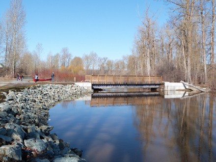
The scene at one of the new bridges in Cottonwood Park on Friday
Prince George, BC – What a difference a day makes in terms of water levels in Cottonwood Park…
The photo above shows walkers and canoers taking advantage of Friday’s sunshine to get down to the park. And the bridge shows the water level sitting at least one-metre below.
The situation had changed dramatically by yesterday, when 250News’ photographer once again stopped by to take some shots from similar vantage points.
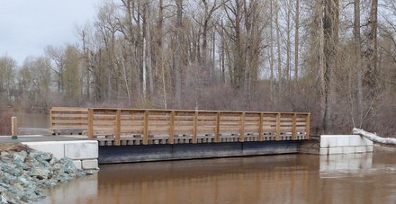 The photo at left shows just how dramatically the water had risen in a mere 24-hours, now just mere centimetres below the bottom of the bridge.
With snowpack levels in area mountains even above 2007 levels, the ‘force’ of this year’s spring freshet will be dependent on weather.
It appears Friday’s warm weather, followed by Saturday’s rain took its toll.
Several bridges in Cottonwood were destroyed during the 2007 run-off.
Comments
Too bad we didn’t have a dike…:)
Well you’ve got until about the 3rd week of June to build it. Better hurry…..LOL….
Correct me if I’m wrong, but I don’t believe the proposed dike is to extend as far East as Cottonwood Island.
metalman.
Those pesky icejams! When will the city realize we need to dredge the confluence?
You are correct, metalman. Cottonwood wil not be proetected by the dike since it follows River Road up to the rail overpass on the east end of the road.
The heritage trail, the park, as well as the museum, etc. will not be protected. The museum’s admin building is sitting on higher ground and is somewhat protected. The location which appears to be sopmeone’s log building hobby, or whatever that is supposed to be has been raised as well.
I am just hoping that whatever the City does with the park and the trail is the kind of investment which is not damaged with seasonal flooding and will just require seasonal. post flood, cleanup.
The river bank, without rip rap or other kind of protection, will continue to erode away over the years.
You know, it is my city, your city and the city of some 75,000 people. Does anyone tell you, me, and the others of what is going to happen there. Of course not.
THAT is what ticks me off! The arrogance of this City Hall. After all, we just live here.
Where is the ice jam????
They won’t dredge it because one company in town has the rights to all the material, and the city refuses to allow them to gather the material, they want idl to do the work, then sell the material
sum42guy2k….Please share with us…Who has the rights to the river material.
The Fraser hasn’t really started to rise yet, this year could be interesting. Just pondering where all the water will end up once it follows the slough from Queensway Street?
I agree metalman, I say quit spending all this money on cottonwood island park and put a stretch along fraser river south cn yard to east end bridge to connect with Lc Gun trail, it is up high and will not be prone to flooding and a nice walk along the river.just thinking
What we need is a huge bridge at tax payer cost that is higher off the ground so it can take the flood waters better. Oh wait they already have that at Cotton Wood. I’d rather have nice roads to drive then a Huge fricken walking bridge over at the entrance of Cotton wood park.
Is that not the bridge they built that can be removed so that it would not be damaged by flooding?
Comments for this article are closed.