River Level Eases At Week’s End
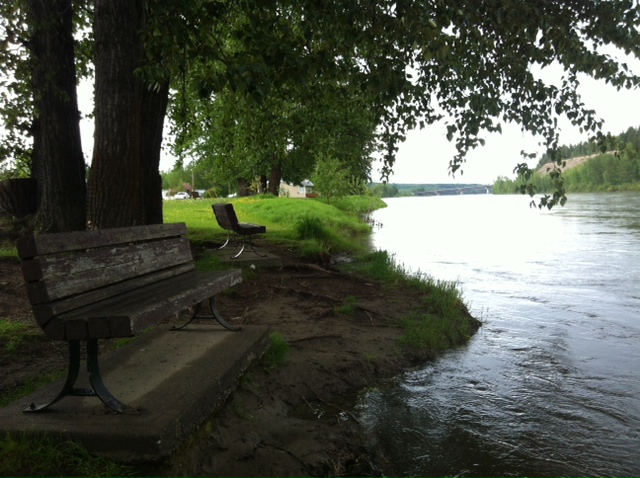
Fraser laps close to benches in Paddlewheel Park on Friday afternoon
Prince George, BC – While there is no update from the City’s Emergency Operations Centre, it appears the threat of flooding from the Fraser River has abated in South Fort George for the time being…
The EOC was activated at Level One on Monday of this week as the level of the river began to rise above 7.5m3/s, but the City’s Communications Director, Chris Bone, said yesterday afternoon, "I have no updated information for you regarding the EOC, the situation remains unchanged since the media release last week (Monday, May 28th)."
Members of the Emergency Operations Centre are scheduled to meet this coming Monday morning to assess the situation.
Meantime, the BC River Forecast Centre’s Five-Day Flow Forecast shows the Fraser’s level at South Fort George peaked on Thursday at 8.042m3/s, and is expected to drop to 7.482m3/s by Tuesday.
The following graph prepared by the BC River Forecast Centre shows the discharge and water level over the past week:
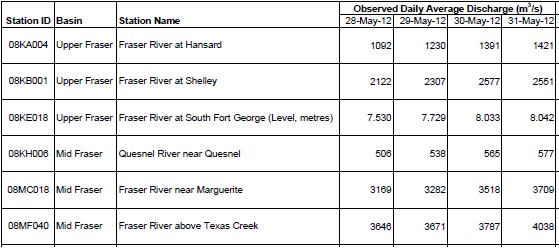
According to Environment Canada’s Water Office, the river level at its South Fort George monitoring station was 7.835-metres as of last night.
Comments
I notice that (as usual) the water is seeping up at the Eastern end of 2nd and 3rd Ave, and that the City has the roads blocked off. In addition they have the pump set up and going and the East End of 1st Avenue. (So whats new?)
On the other hand, the area from Brinks Sawmill to East of the boat launch on River Road is bone dry.
Hmmmmmmmmmmmmmm.
At Brinks work yard to the south of River Rd. the spot elevation shown on PGMap is 570.53 metres.
Parking lot at eastern end of Cottonwood Island Park spot elevation is 566.23 metres.
Spot elevation at the eastern end of 3rd Avenue is 566.77 metes.
Spot elevation at the eastern end of 4th avenue is 568.28 metres
Spot elevation at road to the west of Paddlewheel park is 567.52metres. The pavillion is at around the 567metre elevation
Spot elevation at the intersection Patricia and 1st avenue is 568.79 metres.
Seems perfectly consistent to me that Brinks should be dry and the eastern end of the queensway industrial area has its normal seepage problems.
And the Fraser is not all that high at the moment. It frequently gets to the level of the bench seats in the Shelter which is probably a metre+ higher from where it sits now.
Comments for this article are closed.