Fraser Flood Threat…..Again
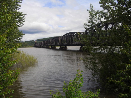
The Fraser River level nearly tops the CN Rail bridge abutments Sunday afternoon
Prince George, B.C.- With the most recent heavy rains being blamed for the swelling of the Nechako and Fraser Rivers, there is also cause for concern with the lingering snowpack.
Both regions are listed at being 178% of normal as the cold blast in May dropped even more snow in the region.
With the Nechako at near capacity because of recent heavy rainfall, and the Fraser expected to spill its banks at any time, the River Forecast Centre says the spring freshet could drag on for another few weeks.
 The Forecast Centre says although there has been significant snowmelt since the manual snow survey was taken, "It may be late-June before the elevated risk subsides through the Upper Fraser, Nechako, Kootenay Peace, Skeena-Nass, and overall Fraser Basin, where peak flows typically occur in early-June."
"In Columbia and South Thompson, where peak flows typically occur late-June, elevated flood risk may extend into July." (click on photo of Cameron Street Bridge at right for a short videoclip of the Nechako river’s fast flow yesterday)
The June 15th snow bulletin is expected to be released on or before June 25th.
 Meantime, with a flood warning re-issued for the Fraser River through Prince George, residents of Farrell Street in Prince George have been advised to pack their things, and be prepared to be ordered out of their homes for the second time this year.
The river level is expected to top 9.6-metres today, while the flood level is 9.4m. (click here for previous story)
The peak from this weekend’s rain is expected to come tomorrow or early Wednesday at 10.2 to 10.6 meters. The City of Prince George’s Emergency Operations Centre remains active with officials meeting this morning to make a decision on possibly reinstating the state of local emergency, which would then give authorities the ability to issue evacuation orders.
Comments
Comments for this article are closed.