Cottonwood Island Park Damage Extensive
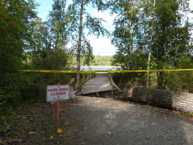
One of the damaged areas in Cottonwood Island Park – photos 250News
Prince George, B.C. – Although there has not yet been a price tag attached to the damage in Cottonwood Island Park, there will need to be some repairs and changes made.
The park sustained significant damage due to high water levels on the Nechako River during the spring freshet. The extent of the damage really only visible over the past week or so as the Nechako returns to levels typical for this time of the year.
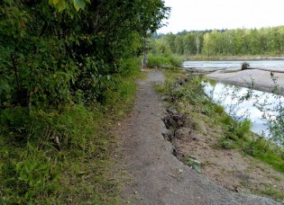
Supervisor of Parks Sean Le Brun says at least one trail will have to be re-routed “One of the trails that runs along the north side of Cottonwood Island is pretty much gone, there are sections that are left, but we did lose a fair bit of the island. So what we need to do is look at where we do have trail and try to connect two points back together.”
(at right, bank erosion cuts into trail)
That means the riverside trail will be a thing of the past “Obviously we’re not going to run a trail right along the riverbank again, so we’ll try to connect the trails without doing too much damage environmentally and what that process is, is really our next step.” He says much of the north side of the island has been undermined by the river “Short of stabilizing the bank and arming it in some way to protect it, at great expense, it just doesn’t seem the right thing to do to build another trail and hope that it doesn’t flood again.”
In addition to the loss of trails due to bank erosion, one bridge was damaged when a cottonwood tree toppled on to it. A structural engineer may have to be brought in to see if the bridge can be repaired, or if it needs to be replaced.
The area is environmentally sensitive, so LeBrun says it’s more complicated than just dumping some new gravel and spreading it around “We don’t want to rush into anything and do things improperly or haphazardly.”
The Parks division has a $75 thousand dollar capital trail rehabilitation budget this year, but that money is to be used to build up and repair all the trails in the City “It’s (the budget) not dedicated to one certain section , we just try every year to try and improve a little bit here and there.”
It is too late in the year to make repairs to Cottonwood Island Park, but LeBrun is hopeful the fall and winter will allow time to have some sort of design plan developed . Depending on the plan, work would not likely start until next summer following the 2016 spring freshet.
In the meantime, park users can expect to see signs “The majority of the island is still available” says LeBrun, “You can still get on and off, you can still get from one end to the other, there are just certain sections that you will notice some new signs. The bridge itself will be closed until we can decide if it can be fixed or if it needs to be removed and replaced. It’s just a matter of keeping your eyes open and being very careful if you walk along the river bank because as we know, there are lots of spots that have been undermined and you will need to exercise caution at all times.”
Le Brun says the full report, complete with cost estimates to repair damage, is expected to be presented to Council some time this fall. “If it is a larger amount, or beyond what’s in the Parks capital program that would have to go before Council for approval.”
LeBrun says while there are still questions about dollars and trail connectivity, there is one thing they do know “We’re going to have to look long and hard at alternatives.”


Comments
I’m surprised the city isn’t going after Rio Tinto -. Don’t they “carefully” control flow in the Nechako river?
Jimmi was thinking the same thing.. Rio tinto does the same thing every spring.. They complain about the level in the dam and then release the flood.. You would think after so many years they would have figured it out.. Or maybe they don’t care as its all about making money who cares off the fallout.
Maybe Rio Tinto wants to remind people that they control the water in the River as per the 1951 Agreement with the BC Government. If we get constant flooding because of water release, perhaps they would suggest that this could be controlled by allowing them to produce electricity from the Kemano 2 Tunnel, and thus reduce the amount of water being released into the Nechako.
A reduction of water in the Nechako to facilitate producing more electricity with Kemano 2, would of course mean that we would probably lose most of the water in the Nechako during the summer months.
Who knows?
I have a vague memory that the Kemano Project agreement makes Alcan immune. Is that right?
70% of the river is wild, and the reservoir acts as a buffer during high water inflows. Without the reservoirs flows may have been even higher. That being said I wonder if Rio Tinto could mange their releases better. River flows have been more benign since the dam went in and development has reflexed that. More development in areas that where once more flood prone. I think Rio Tinto, province and local government has shown negligence in showing potential risk.
Cottonwood trees falling are not caused by rising water unless it is on the edge of the water. The one shown in the picture is not in such a location.
One can avoid such damage by doing danger tree assessments on an annual basis and taking down those trees which are in danger of falling. Before workers go onto a forested site an assessment must be made for danger trees. I do not know whether the City does that for treed City parks on an annual basis. They should to avoid possible injuries to park users as well as park structures.
As far as shoreline trails go, move them well back from the shore. Let the river do what it wants to do. Forget about whose fault it is. The dam is man-made, the trails are man-made. The Nechako River delta has shifted for thousands of years without the assistance of a dam. The shifting might come at different times now than it used to, but it comes either way.
We need someone who understands that to make a long range plan for the area park so that the annual damage is not done by the river. There are many places in the world that have come to realize that. Some began to realize it a century or more ago, others still have not realized it. It is time we joined those who work with nature rather than against it.
I think the most dangerous park spot in PG is the over hang on the cut bank above Pat Bell’s winery. That one high point has a good six foot under cut and someone standing on it wouldn’t even see it coming… I think it’s a matter of time before someone gets killed by that overhang. I would like to see the city maybe bring a compactor up there and shake the overhang loose maybe, or something else to mitigate the under cut danger there.
You want to fix Cottonwood Park ? Dredge the confluence of the rivers .
stcplanning.org/usr/Program_Areas/Flood_Mitigation/Beneficial Functions/Dredging_Factsheet.pdf
Dredging to reduce bank erosion has the opposite effect that intuition tells us. Some basic knowledge in hydrology would help to explain it. The linked factsheet above will explain some of it for those who chose not to believe me.
googling the key words “dredging bank erosion” will provide additional information.
Comments for this article are closed.