Geoscience BC SeArch project produces promising results

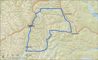
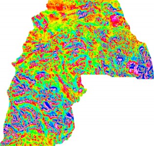
(At right, blue line outlines area mapped during phase one of SeArch project. Images courtesy Geoscience BC)
Phase one of the SeArch project examined more than 6700 kilometres of land in a grid pattern from Smithers to Terrace and south to Kitimat, showing what may lie beneath the surface . This area was previously surveyed in 2008 as part of Geoscience B.C.’s Quest-West project, but the most recent survey which started in August of 2015, used magnetic sensor technology mounted on a helicopter . The grid pattern was spaced at 250 metres, producing more detail than had been previously available.
Geoscience B.C.’s Vice President of Minerals and Mining, Bruce Madhu says the data shows areas which have a highly magnetic response.

In the past, release of the Geoscience data has sparked a rush of claims being staked, and that is likely to happen again with the release of the data of phase one of SeArch.
The information comes at a time when commodities are low and mining operations slowed and in some cases halted, but the information will set the stage for the future. “If not this year, or next year, this information will serve a generation of explorers, it could be ten years down the road. It’s a major long term investment in British Columbia ” says Madhu “The process often takes years and years, and it’s not unusual for a discovery to take a decade to 20 years to reach its full potential.
Geoscience BC President Robin Archdekin says Geoscience was created during a similar downturn a decade ago “In 2005 when prices were off and the industry was struggling, we were created. The notion is that during difficult times, it’s expensive to do this kind of work. we are competing on a world basis, and by having this work done, it just makes B.C. that much more attractive for whatever minimum finances are out there to invest.”
Madhu says phase two of the SeArch project will take place this year “We highlighted an area stretching from Smithers to Vanderhoof and almost to the Blackwater River area west of Quesnel. We intend to survey a majority of that this year, in 2016, in one of the biggest survey’s we’ve ever proposed.”

Comments
First nations suddenly have more land to claim for themselves.
Theres gold in them thar hills
Comments for this article are closed.