Nechako Freezing Up
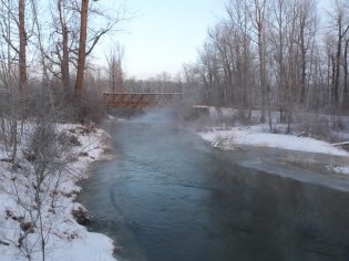
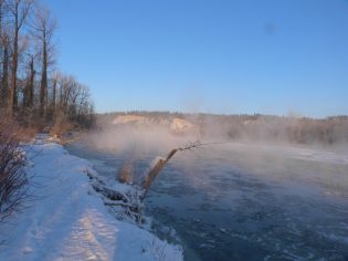
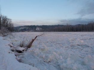
Above, Nechako River this morning, at right, the same area showing open water yesterday -photos 250News
Prince George, B.C. – What a difference a day makes. Yesterday, there was clearly open water on the Nechako River as it flowed east towards the confluence with the Fraser River. This morning, a different story.

(at right, water from the Nechako River fills the channel near the Cottonwood Island Park main entrance)
The City of Prince George and the Ministry of Environment are keeping tabs on the situation. The City’s Manager of Public Works , Dave Dyer, was on scene earlier today to assess the situation.
At this point there has been no closure of trails or areas in the Park.


Comments
Until the river is dredged, taxpayers will be dumping $$$ into this simple to fix problem.
Thank goodness the water still runs under the ice.
Some. The water looked pretty high at the boat launch this morning.
wouldn’t want to dredge that river, save us all millions, because a few salmon may get confused.
Here we go again..Better get the amphibex on stand-by..
The Nechako River has been silting at the confluence of the Nechako and Fraser rivers since they built the Kenny dam in 1951. In other words silting for 65 years. When the Kenny dam was built 30% of the flow of water that would normally go into the Nechako River was diverted through the Kemano 1, tunnel and eventually flowed into the Pacific ocean.
This was and is the cause of severe silting in Prince George. This is not a State secret. In fact anyone who has been in Prince George since the dam was built can tell you what has happened.
The deepest channel on the Nechako used to be on the South side and would flow and merge into the Fraser river. In fact you could distinctly see the dirty water of the Fraser on the East side from Fort George Park and the clear water of the Nechako on the West side.
With the silting over 65 years the Nechako river has been pushed to the North side and that’s now where the deep channel is. This funnels the water directly into the incoming Fraser river and when these rivers are iced up can force the water to back up on the Nechako.
Because of the silting the normal flow on the South side is restricted and causes ice to jam and further exacerbates the problem.
This is not rocket science. Anyone with half a brain and a butt can figure this out.
No Government Municipal, Provincial, or Federal has ever taken any action to solve this problem. Rather they pretend that there is some sort of mysterious transformation taking place, and suggest that we build a dyke along River Road to solve the problem.
As has been suggested thousands of times over the years, the solution is to dredge the South side so that the normal channel can again take over, and merge this water into the Fraser rather than hitting it head on.
Lets hope this Council has some common sense, and will use money from the Feds, and Province, to fix this problem once and for all, and get Cottonwood Island back to a nice park the way it should be. It takes big men/women with big ideas to get things done.
Time to move on this issue.
PS: The salmon issue is a red herring. (Pun intended)
Before the dam any silt build up would be washed out by unrestrained river flows. This would also cause heavy flooding not seen since the dam went in. Check out historic photos with steam engines making like steam boats.
Yes dredging is required.
“The Nechako River has been silting at the confluence of the Nechako and Fraser rivers since they built the Kenny dam in 1951”
That is a true statement if one only looks back as far as 1951.
The truer statement is that the Nechako has been silting at the confluence of the Nechako and Fraser Rivers since the time that the glaziers started to recede.
Look at the middle of the linked page which explains river formation, particularly half way down the page to “braided channels” which is the characteristic displayed at the junction of two rivers, followed by the “middle course landforms” which displays the meander scars on the outside of the river bends (removal of bank soils) and the point bars (deposits of bank soils) on the inside river bends.
Then continue to the “floodplain evolution” component. Watch the animated video of “meander initiation which shows the action of water flow in a bed of sand. You can watch the same thing here: youtube.com/watch?v=8a3r-cG8Wic.
Dredging is a zero sum game, generally done to maintain navigable channels in rivers which have a high commercial transportation value.
More recent thinking for rivers such as the Mississippi in the US as well as the Rhine in its travel from Switzerland through Germany and Holland to the North Sea is to allow the river to have a wider bed. Applying that to the Nechako, accept the natural water flow and accompanying erosion forces and accommodate the predictive results by varying approaches to man-made near-river activities.
In the case of the land in proximity of the confluence of the rivers that means:
1. locate buildings further from the banks on the outside bend that means investing the most on improved walkways further inland
2. give the river a wider channel by utilizing the land for natural “parks” with any man-made infrastructure to be located far enough from the bank to be affected as infrequently as possible.
Thus, as far as trail systems go, the ones closest to the riverbank would receive the least investment and be left for users to create their own trails as is done in Saskatoon on the banks of the South Saskatchewan river, then the next level is a trail built up of “soft” materials, followed by hard surfaced walkways (Meewasin Trail) and finally vehicular travelled roadways (Spadina Crescent E.) with major buildings to the west of the road.
For joggers: cjme.com/article/398652/saskatoon-running-club-says-older-trails-starting-show-their-age
For mountain bikers: youtube.com/watch?v=rbWIurigOsE (about 2 thirds of the way into the video you can see the “trail” at the flood level.
oops … forgot to add the link referenced in the fourth paragraph.
thebritishgeographer.weebly.com/river-landforms.html
Anyone notice how fast they got to work on dredging and putting ballast in the river along Pulp Mill Road between the winery and some of the houses along that stretch of river.
Are we to believe that somehow the salmon are not effected by this work being done on the North side, but they are on the South side??? What about the sturgeon that generally move about in the deep water on the North side.
Was the City able to get the OK from the Department of Fisheries for the work they are doing. If so, how much of a problem was it.????
Who owns the winery and the home next to it?
What dredging? Riprap was added to the bank.
250news.com/2016/07/28/work-underway-to-shore-up-nechako-river-frontage
The lower Fraser river around the George Massey tunnels has a major silting problem. Floating homes and marinas in the area are constantly having to have the river dredged under them to keep them floating and useable. Apparently there is no fish habitat to destroy in that area. Who knew? Dredging the lower Fraser is a year round job.
It is a river delta of a major river. It is natural. They are fighting nature.
Much cheaper to locate it where there is no build-up of silt in the first place
two pictures showing the action of the Fraser River depositing its silt in the delta.
pbs.twimg.com/media/CnGPir9UkAA_6ZF.jpg
oceannetworks.ca/sites/default/files/images/pages/sog/ed_mcnichol_boundary_smaller.jpg
The sharp boundary appears in the Strait of Georgia during the annual Fraser River freshet. This sediment-laden fresh water spreads in a shallow plume and is visible because it is less dense than salt water.
I don’t think we need to look at rivers all over the world to solve the problem with silting at the confluence of the Nechako and Fraser Rivers.
We can do whatever dredging is necessary to return the flow to the South side of the river as it was for many years in the past. If you look at this area when the water is low you can readily see that the problem is the build up of gravel (silt) along the South side and up to and under the rail bridge.
The silting is not a result of the natural way of rivers, it is the result of reducing the flow of the river creating silt, that then forces the water to North Side. Reduce the silt and the river will naturally return to its normal flow. It might require further dredging over the years, however when you consider that we can use the gravel for other means, there is some benefit to the City.
Comments for this article are closed.