Clear Full Forecast

Welcome to Canada

By 250 News

Wednesday, November 29, 2006 04:02 AM


While we may be in the midst of an early winter deep freeze all you need to do is look at Environment Canada’s weather warnings to see we are not alone.

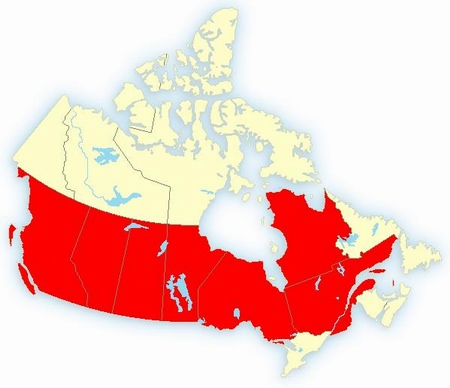
With the exception of the Toronto - Ottawa region and the Atlantic provinces, the country is blocked in red, signifying  there are weather warnings for everything from cold, snow, blowing snow and freezing rain.

The weather warninbg in effect for Prince George  is a snowfall warning:

Total snowfall accumulation of 15 cm expected today and tonight.

A pacific frontal system will move into the interior from the west today. Snow has developed in Smithers early this morning and is forecast to spread elsewhere in the central interior by early this afternoon. The snow will persist tonight giving total accumulations of near 15 cm except near 10 cm for the 100 Mile region. The snow will ease to flurries by Thursday morning.

Winds of 15 to 20 km/h ahead of this frontal system is resulting in extreme wind chill temperatures near minus 40 in the bc Peace and near minus 35 in the South Thompson. These wind chills will moderate this afternoon.

What makes the most interesting reading is the fact that Environment Canada predicted we would have an early winter with plenty of cold.

For skiers and Snowmobilers, they also made another prediction.  Prince George  is teetering between the  areas mapped to have normal snowfall, and the area mapped to have heavy snow.

To the North of the Pine pass, 30 inches of snow covers the area in some places. The drought that hit the area this year has become a thing of the past as farmers and ranchers struggle to find enough feed to carry cattle over the winter.

In this region we are expected to experience a bit of a heat wave come Friday when the temperature climbs to -9 before falling back to -15 (and lower) over the weekend.

Vancouver will return to milder temperatures with a high of +4 on Thursday and +5 on Friday.

Here are the lows predicted for Thursday and Friday

                                   Thursday               Friday

  • Prince George         -9 in snow           -15
  • Kelowna                 -7                       -11
  • Kamloops              -11                       -13
  • Mackenzie             -13                       -19
  • Williams Lake        -13                       -17
  • Quesnel                 -11                      -16
  • Ft. Nelson              -33                       -25
  • Smithers                -15                      -15
  • Terrace                   -8                        -5
  • Prince Rupert            2 rain                   3
  • Ft. St. John            -16                       -17
  • Calgary                 -14                      -12
  • Edmonton              -18                      -14
  • Grande Prairie        -16                      -16


Now for a look at the future, Environment Canada says we are right on the border of normal winter and below normal temperatures.


Previous Story - Next Story


Return to Home
NetBistro

Comments

Back to the good ole days.
Watch out! Global cooling is starting to take hold. If we don't have the political will to act now, our food supply will soon be at risk!
Its amazing how the weather seems to stop at the international border. It is just as much fun to watch the Seattle stations these days as it is to watch the Vancouver news. 15+ minutes on weather and its effects.

There are snow warnings and winter strom warnings all the way down to Portland Oregon. There are frost warnings all the way down to mid California .....

We are not alone .... it is all relative .... :-)
---------------------------------------

URGENT - WINTER WEATHER MESSAGE
NATIONAL WEATHER SERVICE SEATTLE WA
1006 AM PST WED NOV 29 2006

WAZ506-510-511-300215-
/O.UPG.KSEW.WS.A.0009.061130T0200Z-061130T1200Z/
/O.NEW.KSEW.WS.W.0007.061130T0000Z-061130T1800Z/
WESTERN SKAGIT COUNTY-ADMIRALTY INLET AREA-HOOD CANAL AREA-
1006 AM PST WED NOV 29 2006

...WINTER STORM WARNING IN EFFECT FROM 4 PM THIS AFTERNOON TO
10 AM PST THURSDAY..

THE NATIONAL WEATHER SERVICE IN SEATTLE HAS ISSUED A WINTER STORM
WARNING FOR THE KITSAP PENINSULA AND NORTH INTERIOR...WHICH IS IN
EFFECT FROM 4 PM THIS AFTERNOON TO 10 AM PST THURSDAY. THE WINTER
STORM WATCH IS NO LONGER IN EFFECT.

MOISTURE ASSOCIATED WITH A PACIFIC WEATHER SYSTEM WILL OVERRUN
COLD AIR TRAPPED AT THE SURFACE. SNOW IS EXPECTED TO BEGIN LATER
THIS AFTERNOON AND CONTINUE THROUGH THE EVENING HOURS. A
TRANSITION TO FREEZING RAIN OR SLEET IS POSSIBLE AFTER MIDNIGHT AND
CONTINUING THROUGH THURSDAY MORNING.

ACCUMULATIONS OF 4 TO 6 INCHES OF SNOW ARE ANTICIPATED BEFORE THE
TRANSITION TO MIXED PRECIPITATION OCCURS. THERE IS A POSSIBILITY
OF LIGHT ICE ACCUMULATION DURING THE TRANSITION EARLY THURSDAY
MORNING.

PEOPLE IN THE WARNING AREA SHOULD EXPECT TREACHEROUS DRIVING
CONDITIONS. IF YOU MUST TRAVEL...DRIVE WITH EXTRA CAUTION AS ROADS
WILL BE ICY OR SNOW PACKED.

----------------------
URGENT - WINTER WEATHER MESSAGE
NATIONAL WEATHER SERVICE ALBUQUERQUE NM
1158 AM MST WED NOV 29 2006

NMZ006-007-012-013-300300-
/O.UPG.KABQ.WW.Y.0013.000000T0000Z-061130T1100Z/
/O.NEW.KABQ.WS.W.0005.061129T1858Z-061130T1100Z/
HARDING COUNTY-FAR NORTHEAST PLAINS-CONCHAS LAKE/GUADALUPE COUNTY-
QUAY COUNTY-
INCLUDING THE CITIES OF...ROY...CLAYTON...SANTA ROSA...TUCUMCARI
1158 AM MST WED NOV 29 2006

...WINTER STORM WARNING IN EFFECT UNTIL 4 AM MST THURSDAY...

THE NATIONAL WEATHER SERVICE IN ALBUQUERQUE HAS ISSUED A WINTER
STORM WARNING...WHICH IS IN EFFECT UNTIL 4 AM MST THURSDAY. THE
WINTER WEATHER ADVISORY IS NO LONGER IN EFFECT AND HAS BEEN
UPGRADED TO THIS WINTER STORM WARNING.

A COLD FRONT ACROSS THE STATE ALONG INTERSTATE 40 WILL PRODUCE
HEAVY SNOWS AND BLOWING SNOW THROUGH TONIGHT.

AS HEAVY SNOW MOVES FROM SOUTHWEST TO NORTHEAST ACROSS NORTHEAST
AND EAST CENTRAL NEW MEXICO TONIGHT...EXPECT 3 TO 6 INCHES OF NEW
SNOW THROUGH TONIGHT. GUSTY WINDS WITH THE SNOW WILL SHIFT TO THE
NORTHEAST AND INCREASE SPEED THROUGH THE EVENING AND
OVERNIGHT...WITH LOCALLY POOR VISIBILITIES IN BLOWING SNOW.

SNOW WILL TAPER OFF RAPIDLY THURSDAY MORNING WITH DECREASED WINDS
TO EASE THE WINTER STORM DANGER.

DRIVERS SHOULD EXPECT THE FULL SLATE OF WINTER DRIVING
CONDITIONS...WITH DRIFTING SNOW OVER EXPOSED ROADS...PATCHES OF
SLICK ROAD...AND NEAR ZERO VISIBILITIES IN BLOWING SNOW. CONSIDER
DELAYING TRAVEL UNTIL LATER IN THE WEEK IF POSSIBLE. THOSE
OUTDOORS SHOULD DRESS WARMLY AND BE PREPARED FOR WINTER WEATHER.

REMEMBER...A WINTER STORM WARNING MEANS SEVERE WINTER WEATHER
CONDITIONS ARE IMMINENT OR HIGHLY LIKELY.
-----------------------------

I always find it amazing how people ask how we could possibly live in such cold and snowy weather as we have in Canada ... ;-)
All one really needs is a good long john to wear under your regular cloths and you won't notice the cold one bit.
Urgent Winter Weather Message: Severe Winter Weather, A Cold Front, Winter Storm Danger, Drifting Snow, Near Zero Visibility in Blowing Snow, Storm Warning, Treacherous Driving Conditions, Blah, Blah, Blah, Blah, Blah

An average winter day in Prince George brings caos to the rest of the country. Where is the national guard? Where is the financial assistance? What about food and clothing for the homeless? Where is all the help?

Well, in Prince George, we just look after ourselves. Thank God we don't really need to rely on others for our survival.

I am so glad to live where I do where people care for each other and always meet the needs of others on a regular basis. Chester
I think an average winter day in the eastern part fo Canada would bring chaos to Prince George. In fact, from the two or three times in the last 30 years that such an event or series of events has happened that might approximate a real snowstorm followed by real drifting snow, I know that it has brought chaos to Prince George.

I have yet to see a blizzard in PG.

Here is the result of the weather moving eastward:
http://www.msnbc.msn.com/id/15968456