Clear Full Forecast

City Says It Holds All the Cards On Land

By 250 News

Sunday, April 01, 2007 04:00 AM


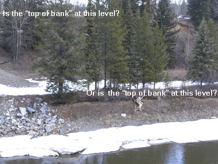
Photo shows  problem of deciding what would be considered the "top of bank".  In this case, if the  property pin was placed at the highwater mark (the lower  level) a property owner could  stand to lose  the use of several meters of  property.                 

Dan Milburn, Manager of Current Planning and Development  for the City of Prince George, says the City has the right to change the zoning by laws along the river which would prohibit people from building homes closer than 30 meters (98 feet) from the river bank.

Milburn says "We do not have to pay compensation under the local government act."  According to Milburn "We have the power to re- zone or change the application for a building permit, without any compensation." 

The proposed new Zoning By law comes back to Prince George City Council this coming Monday for a continuation of a public  hearing.   Included in that by law is a section which deals with the Nechako and Fraser Rivers and the matter of building a home on river property.

The new zoning by law being introduced, with the approval of the Department of Federal Fisheries, calls for a home to be built  "not less than 30 meters from the top of bank, or 50 meters from the top of bank where sections are showing active slumping."   In a report to the City,  DFO says that if any existing City By law or plan includes set backs greater than this, DFO says it fully endorses said by law or plan.

 On August 20th, 1992, the Developer, the Province and the City entered into an agreement to develop some lots along the Nechako River.  The agreed set back was 40 meters from the high water mark, which is where the property  pins were located. Under the new zoning proposal most homes located along the Nechako and Fraser River would be non- conforming. 

Under the existing laws it isn’t clear where DFO’s authority extends.  

In a letter to the City, the DFO writes that it has reviewed and endorses the proposal by the City. It makes no mention of its authority. In that same letter, DFO is also requesting that fences be constructed along the river course between the river and the homes. The covenants signed by the people who purchased these properties agreed not to construct any fences on any part of their land. 

Some homes located at the top of the bank in subdivisions are much closer than 30 meters and the question of what home owners would do if they wished to remove the house and build a new structure on the exact same location  remain unanswered.

The City’s new bylaw says if  there is a difference of opinion  on the location of the "top of the bank", the matter is to be referred to the City/DFO Monthly project Review meeting for final determination. The property owner would be required to hire a Qualified Environmental Professional who would make a case on behalf of the property owner as to the exact location of  the top of bank, or whether a reduction in that distance could be achieved.

 At least two individuals spent thousands of dollars on having reports  on the location of "top of bank" produced by Qualified Environmental Professionals.  The reports were dismissed by the City and DFO.  One such applicant said when they were turned down by the City and DFO, they asked, who they would suggest they should hire for the work.  They said they were told the City and DFO  would not recommend anyone.

The extent of the Authority of the DFO is not known.  Yes, DFO controls the fisheries but it is the Province that owns all of the Crown land  and what authority the DFO has over both the province and private property owners is not known.

Dick Harris MP for Prince George-Cariboo says he became involved in one such discussion about  the exact location of "top of bank" and the matter was settled.  Harris says there  were some other concerns  raised "During that time, I heard complaints that DFO enforcement officers were attending meetings with the side arms on and it became very intimidating for those in attendance. I am looking into this."  Harris says  he will be in Prince George this week and intends to further explore the matter.


Previous Story - Next Story


Return to Home
NetBistro

Comments

Ooooh city getting tough....so un nice of them....
Isn't it wonderful they sell you the land and then take it back...for free....
TRY ME!
...what home owners would do if they wished to remove the house and build a new structure on the exact same location remain unanswered...

Oh, you didn't ask then. The answer is the new bylaw would apply.

HeeHee! ...Qualified Environmental Professionals. The reports were dismissed by the City and DFO... I t happens most of the time, happened to me.

There are certain legislative presumptions, which may be overcome by clear statutory language. Legislation is presumed not to authorize the expropriation of land without compensation unless the statute clearly shows a contrary intent.5 If the statute is clear that compensation will not be paid, that direct statement of intent will be the law. For example, the Municipal Act rebuts the presumption that legislation will not be interpreted to authorize expropriation without compensation unless there is clear language to that effect. Section 914 of that Act states that changes in zoning will not give rise to a right to compensation unless the bylaw restricts the use of land to a public use. Courts have said that this section of the Municipal Act must be narrowly interpreted. The exception should be limited to the ambit clearly expressed.6
"the question of what home owners would do if they wished to remove the house and build a new structure on the exact same location remain unanswered."

There is often a way around laws. There was a law to this effect in Quebec along the Gatineau River. What people did who wished to buy a house and build a new one is simple.

They designed the house in such a way that a portion of the new home started off as an addition. That was permit #1.

They then tore down a part of the old home and rebuilt it as a new section. Sometime a gutted part of the old house was used to as a component in the new building. That construction was done in either one or two additional permits to the first one.

The new result was a conversion of what used to be a "cottage" of some 30 or 40 years of age to a new and much larger home.
I wonder if anyone will argue that the high water mark is the elevation of the outer limits of the 200 year flood plane.

Would seem sensible to me.

There goes the entire area of the “downtown” industrial area, including the CN yard. No more new warehouse there. Virtually everything east of Queensway and some of the adjacent areas to the north and south of the western part of Queensway, including portions of the City Hall property right up to Parkwood , then the Courthouse right up to and including the CN station. Then there is a good portion of the north of the Hudson Bay slough through to Strathcona Park, Carrie Jane Gray Park and the southern part of the new auto dealership there.

Going further upriver of the Nechako we have the Ongman road area, including the parking lot in Parkhill Centre, the concrete plant, the condos on the riverfront. The closes part of that to what is shown as the property line on the PGMap on the city website is about 60 feet, BTW. The houses to the west along there are as close as 70 feet or so to the actual river’s edge shown in the aerial photo taken in the spring of 2006, a time when the water level was low.

Further along at Stevens Drive there are several houses within 50 feet of the water level in the photo. The lots are so small that it would be impossible to build anywhere on the property under the new zoning.

It is easy to see, from my point of view that this is expropriation and that a class action in court would be won by those people affected.

This is one of the reasons why BC needs a Municipal Board. If the Minister responsible for Municipalities has not been involved yet, I think it is time that is done.

The intention might be good, but this is not the way to go about it.
look at the road along the Nechako - that is Stevens ... then apply the new regulations to the "mean high water mark" I am sure the "top of bank" would be higher than that.

http://www.city.pg.bc.ca/pgmap/legals/16573.pdf

There are houses on lots 57 and 58. If they were to be destroyed by fire they could not be rebuilt. Those properties, without improvements, are assessed at $100,000+. The assessments would go down and they would go down very clearly due to new laws and nothing else. In my mind, that is compensable.

If you want to see more like that, do some exploration of your own at:

http://www.city.pg.bc.ca/pgmap/pgmap.html
If the floods that are predicted for this spring actually materialize, there will be not doubt as to where the high water mark is.
Maybe the city needs to set up a reserve fund to compensate 'in the event value can not be realized' (as a result of the city by-law) due to a fire, or some other natural event not related to the river itself. This way if one can not rebuild they get some form of land repurchase compensation at that days market comparable rate.

I am not however in favour of giving land owners along the river a subsidy of tax dollars for what was an historical easment expropriated for private ownership. Common sense tells us we can't let it happen again, but what is done is done.

I support a future easment along the river of at least 200 feet from bank top for public access river trails prior to any future building on the river front property.
I am not however in favour of giving land owners along the river a subsidy of tax dollars for what was an historical easment expropriated for private ownership.


“I support a future easment along the river of at least 200 feet from bank top for public access river trails prior to any future building on the river front property.”

There are many reasons why land adjacent to waterways is of public interest. Three of those are

1. public safety with respect to flooding and saving the public and private landholders from harm. This is in the same realm as building codes etc.
2. water quality as well as animal habitat protection done through ensuring riparian (land adjacent to waterways) zones are environmentally protected.
3. public access to a key natural feature which ought to be enjoyable by the community.

We have the 200 year flood plane in place to cover point 1

We have a 100 foot separation of on site sewage disposal from the waterway in place for number two. We have little in place for riparian protection when it comes to private land, especially. What is in place is the provincial MoE and federal MoF standards for fish bearing waterways

We have nothing in place for the final one other than that we have a public/private regime – the public will access land for public use as opportunity arises. In some areas in North America laws which severely restrict private use are well in place and have been for a very long time. In others they are not. I believe in much of the Oregon Coast, for instance, beaches are essentially public highways dating back some 200 years, that is why in many locations one can still take vehicles onto the beach and drive them in the surf, although protection laws are now in place in most areas.

http://www.csc.noaa.gov/magazine/back_issues/apr98/sec4c.html

As I understand it, the local situation is based on riparian protection concerns, which is primarily of concern to the MoE and the MoF, not the City. Sometimes the two ministries, however, like the City to do the dirty work. That appears to be the case in this situation.

Someone will have to come up with some very sound arguments to convince me that providing any width of protection along riverfronts and then handing it over to public use for trails, etc. is in the interest of water quality and riparian zone habitat protection and enhancement. I think individual, private ownership will provide such protection much more easily.

To put some sort of fence up along the property line to divide it from the public portion of the river makes it even worse. It is no different than what happens in subdivisions. Go along street frontages which have no fence at the property lines and you will typically see that owners will take care of the site right up to the curb, and sometimes even sweep the street gutter of debris. Walk along those area where there is a fence between the public right of way and the property and you are more likely to see fences in disrepair and the boulevard full of weeds and uncut grass. It is a no man’s land. Neither the city nor the homeowner takes care of it in many if not most instances.

Waterways will be no different. There will be no control of what happens in that zone. It will protect nothing. There is better protection with individual, residential land ownership. If there are landowners who are not meeting riparian area management standards, one knows exactly who it is and can deal with it with a knock on the door and a system of fines if it still does not happen. There is no one to fine in the case of public access. It is complaint driven and one will not catch anyone other than the most blatant users such as motorized vehicle users.

So, let us know why the interest in this land. Then provide a legally defensible description of the land by having an environmental consultant take a standard developed by the MoE and MoF and apply it to the waterfronts of the city, including private and public areas and map that area on the City’s GIS map as an overlay with some legal strength to standards to be maintained by all parties who have property interests affected by the new standard.


There are some blatant abusers right now. Naming just three, others can add their own pet peeve ones.

1. the industries in the Ongman road area - just look at the riverbank from the south bank of the river
2. the watercourse which goes from the Carrie Jane Gray area to the Hudson’s Bay slough. That is like an open sewer full of garbage and in the hands of the public.
3. the Macmillan creek area, a fish bearing stream which is receiving inadequate protection.

I think the City is going into this with a very heavy hand using the wrong tools to achieve what is likely an improved standard fro riparian zones within the city.
"what was an historical easment expropriated for private ownership."

I am not sure what historical easement you are referring to. Was there a similar law to the one in Oregon in place upon the creation of the Province?
Historically we didn't have roads and used the rivers for transport. If you hike anywhere around the river where it hasn't been developed yet you will find old Indian trails on both sides of the river that were used for navigating the area. Many people use these old trails for enjoying the river to this day.

Private owners blocking access to these historical common use easments should not be allowed IMO.

My additions to the pet peeve list of violators would be the BCR Site and the North Nechako developments. Also I'm sure we can soon add the Fraser Flats development to the list as well.
Owl, you talk like the rest of us that have taken our paid consultants reports to city staff. You have high hopes. But city staff can disagree, and you must go away. Swearing is not allowed.

It can be a deeply personal experience and everyone should be required to submit to it. The exercise is costly and you must pay for it yourself. Owl you can talk logic all day, but if there is no legal remedy - city staff are god all mighty.

Court is the only avenue. Most times it protects us against the city better than you think.

If an owner were to be substantially effected by a setback regulation under the Fish Protection Act, he or she would have the right to apply to a board of variance for an exemption based on hardship. The boards of variance have generally accepted property owners’ claims of hardship, and allowed exemptions from bylaws.
YDPC - Talk to the Minister responsible for Municipalities and push to get a better appeal process in place than the courts.

http://www.omb.gov.on.ca
"historical common use easments"

That has been recognized under certain circumstancesd in Britain. I am not aware of any or many Canadian cases. Are you?

The tradition here has been the "mean high water mark is the extent of property which can be owned and registered in the land title office. I think there has been enough precedent to make that the "common" situation.

I would love to see a legal opinion on that from someone who has dealt with that situation before.