Clear Full Forecast

Costs Unknown For Flood Mitigation Plan

By 250 News

Monday, April 16, 2007 08:44 PM


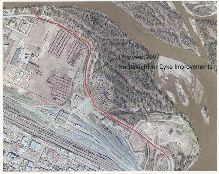
Red line  shows area City  will apply to have  built up  for flood protection

The City of Prince George is applying for funding under the Urgent Flood Mitigation Works program. That is the $33 million dollar fund announced by the province at the end of March to upgrade flood protection throughout B.C..

The City’s Director of Development Services, Bob Radloff, says negotiations are underway with the Ministry of Environment to improve the 35-hundred metre stretch of River Road, from the Yellowhead Bridge to the Cameron Street Bridge.  But Radloff says it’s too early in discussions to pin a dollar figure on the project.

In a report received by City Councillors this evening, Chief Engineer, Dave Dyer, points out River Road does not meet Ministry of Environment flood protection levels and, while the entire road should be shored up, the most vulnerable section is 1640 meters from west of the Nechako Boat launch to the C.N. bridge.

The project identified by the City engineers calls for River Road to be raised. The lowest boost to the height of the road would be 0.2 of a meter, up to the highest increase of 1.7 meters (0.67 feet to 5.5 feet).

Councillor Don Zurowski wanted assurances any mitigation efforts would not tax the city’s capital funds.  "This is 3.5-kilometres of road," says Zurowski, "Commonly, that’s expensive when we talk about that distance, so I’d be delighted if that didn’t impact us from a capital perspective."

Radloff says, "In short, we want to get 100-percent funding from the province."  He says if anything changes during the course of discussions with MoE officials, staff would have to come back to council with that information.

To be eligible for the grant,the work must be nearing completion by the 15th of May. Dave Dyer says the time line is tight, he says an aggressive approach can meet the required deadline.


Previous Story - Next Story


Return to Home
NetBistro

Comments

"The City of Prince George is applying for funding under the Urgent Flood Mitigation Works program"

Urgent??? It's been like that for decades. Where is the urgency? I gather the only reason it is urgent is because the money is there.

Then we have this bit of a restriction:
"To be eligible for the grant,t he work must be nearing completion by the 15th of May."

Less than a month? It would take that long just to get tenders. Are there drawings? ... such as where are the accesses to the park, the R&F Museum, the mills, etc and how will they be accommodated with a 2 or 3 foot rise?

Well, can't say they are not trying.
The heavy hand of gov't. Total lack of awareness, or reality. Planning is something they hire out, after great obfuscation, and consulting their astrologists to determine the best time to announce their latest triumph. That Owl person is aware of what the gov'ts should already know, it's just that they have to hire some out of town experts to study the situation for 6 months, then tell us what to do. How about we reroute the river? that would solve the flood problem for sure eh?
metalman.
So whats the story here. We have a possibility of some severe flooding along River Road and through-out Cottonwood Park

The Provincial Government may or may not have some money available for flood Mitigation. The City (With their blood hound ability to sniff out free money) has applied for some funding to shore up River Road.

Zurkowski doesnt want the mitigation to come out of the Citys capital funds. Radloff assures him it wont. Work must be nearing completion by May 15th.

Question: If the City is aware that this flooding is possible, and it does not take any action other that to apply (late) for some funding from the Provincial Government, then do they have some responsibility if serious flooding takes place, or do they blame the Province. Will they take some action on their own when the water starts to rise??

Are they capable of doing anything other than applying for grants from various levels of Government, spending money, and taxing Citizens.??

Lets see how they handle this one.

How highs the water mamma?? Its four feet high and rising'

I really would like to know why they are looking at raising River Road rather than raising the river walkway.

I suspect that raising the river walkway would be cheaper to do, would protect the railway and forestry museum property as well as all property along the river to the north of River Road.

In Cottonwood Island Park, the walkway/dike could follow the south bank of the southernmost channel so that the “wetlands” are properly protected.

The mouth of the Fraser is protected pretty much that way. Creating something like this, while disturbing limited amounts of the park and trees adjacent to the water, would enhance the river walk, protect more property form floods, and end up with a better facility rather than simply a rebuild of an existing facility.

I would love to know what the rationale behind choosing the location shown on the map is.

http://flickr.com/photos/45432192@N00/207780325
Look at this caption "on the site of the old BC PAckers Fish cannery" ....

I wonder how long it will take for us to be able to show a picture like that along the river and write "on the site of the old Klein river gravel mining operation".... or the old Lakeland Sorting Yard" .. etc.

http://flickr.com/photos/45432192@N00/207780322/in/photostream

this is what happens over and over again in the world ... river oriented industry of old gets shut down due to change and recreation, housing, etc. take its place.
And ... I forgot ... for the nay sayers to that sort of thinking .... the communities survive and thrive since other "industry" takes its place in other, more appropriate parts of the community.