Mapping A Future for the Central Interior
By 250 News
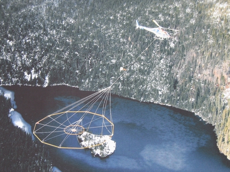
Helicopter carries what appears to be a giant spider web over areas to be surveyed for evidence of mineral deposits.
"Some people say it looks like a giant spider web, but I think of it as a dream catcher." those are the words of Minister of State for Mining in B.C.Kevin Kreuger. He was one of several officials on hand for the announcement today that millions will be spent on identifying possible mineral deposits in the stretch of province hit hardest by the mountain pine beetle.
Special equipment like the "dream catcher" shown in the photo above, will be used to detect the minerals hidden beneath lava flows and glacial deposits in the region from Williams Lake to Mackenzie.
“We know there have been major mineral deposits found in the mountains to the north and south of this range” says David Caulfield the past President of the Association for Mineral Exploration. “There is no reason why there wouldn’t be similar deposits in the plateau through Prince George because its all part of the same range. Right now, this whole area, (Williams Lake to Mackenzie) is like a black hole, we can’t see what may be under the layers of lava and glacial deposits, this mapping project will give us a much better picture.”
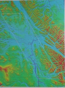
(blue area in photo at left is region that will be mapped)
One process involves using an apparatus that resembles a spider web, suspended from a helicopter. That chopper will fly a grid pattern from Mackenzie, south to Williams Lake, then north again. The project will start in July, and all the data will be collected by October. The final results will be made available to the public.
Geoscience B.C. is calling this the Quesnella project.
It is aimed specifically at finding potential mineral deposits in the corridor suffering from the ravages of the Mountain Pine Beetle.
Caulfield says if there are minerals discovered, Prince George, Quesnel and Mackenzie are in an excellent position because many mineral deposits in B.C have been in remote areas. These are centres which can already provide support for mine exploration, construction or operations, and the existing logging roads provide better access to potential sites.
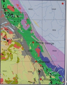
(map at right shows detail of area to be studied)
While the full cost of the project is $5 million, four million will come from the Provincial Government, and the balance is expected to come from some other source.
Geoscience B.C. does have an application for that one million dollar balance before the Northern Development Initiatives Trust. Its Board of Directors will meet in a couple of weeks to consider that proposal.
Previous Story - Next Story
Return to Home