Clear Full Forecast

Diking the Only Way to Prevent Repeated Floods

By 250 News

Monday, December 17, 2007 03:59 AM

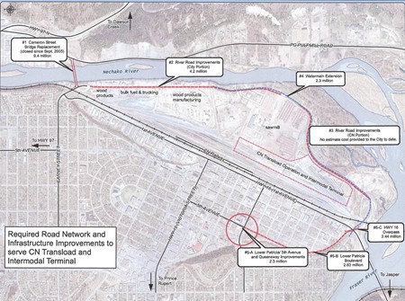
  Plans for road improvement, including River Road.  

Prince George, B.C. – The only thing that will protect Prince George from future flood episodes is a proper diking system.  That is the word from ice jam expert Paul Doyle.

The gabion diking that has been put in place to mitigate the flows from the Nechako will stay in place until spring “We understand from our consultants that this could occur again” says Prince George Mayor Colin Kinsley, so the gabions will stay put.

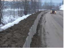
(at right, gabion diking along the  river’s edge on P.G. Pulpmill Road)

Still, Doyle says the temporary solution is not the way to go “The only really long term solution to this kind of problem on the Nechako, and it’s not isolated by any means, is some decent diking along there.  That will stop the problem.  Anything else is a stop gap catch as catch can.”

The City of Prince George has been putting together a plan to raise River Road, a plan it hopes to  receive funding for under the Asia - Pacific Gateway  programs as River Road is a key to access to the intermodal  operations at CN.

That plan calls for  $4.2 million dollars  for improvements to River Road,  a further $2.3 million for  a watermain extension on River Road,  and  a third section of improvements along the CN  east side of  the intermodal yard, but there is no cost estimate for those repairs.

Over the weekend, the ice jam which has caused the Nechako to spill its banks,  changed. It had been 6 km long, and is now  2 km from the mouth of the Nechako to  the  boat launch at Cottonwood  Island.


Previous Story - Next Story


Return to Home
NetBistro

Comments

We are headed for a great snow pack this year, so get ready for flood stage all summer again.
This is the vision that I see for a hypothetical possibility this winter ahead.

The ice builds up again with the next cold spell we all know is coming. The Nechako no longer flows past Winton Global to the Fraser and changes course to the path of least resistance.

This is not new and can be witnessed each year in spectacular fashion at the Salmon Valley bridge area of Highway 97 20 minutes north of town where the river can build a whole new river channel 400 feet from the one it ran in the previous year, due in large part to ice jams that block the shallow spots on the river and force the river in a new direction where it carves its own new channel.

So we have the Nechako blockage creating the situation of a new channel of least resistance. We nearly had that full blown this time around, but we were spare by mother nature at the last moment from disaster.

The new Nechako Channel IMO will by this coming spring flow from Brink Forest Products across the CN Rail yard to 1st Avenue, and down 1st Avenue to George Street East where it will pool flooding out 50% of the downtown including City Hall, the Plaza 400 building, the court house, the civic centre, and eventually Parkwood Shopping Centre, draining down into the Massey Drive recreation area where it will pool again into a large lake, and then flow out into the Fraser through the slew area taking out a vast majority of the hood VLA area in the process.

The Nechako River quite literally could revert back to its original channel it flowed in when Alexander Mackenzie first mapped the area and missed the Nechako River as the only major landmark he missed. Why did Alexander Mackenzie (the worlds foremost map’er) miss the Nechako River when he found the Black Water River as his path to be the first to reach the Pacific Ocean over land? Because at that time the Nechako flowed through the area I just described above and not through the current channel we all recognize today. At the opening to the slew the Nechako looked like a back channel of the Fraser. It wasn't until years later when Simon Fraser came through the area that the Nechako River was discovered after it broke through and carved the channel it now takes to the Fraser River.

Should this happen it again it would be a well needed enema to this city that would surely be a disaster in the short term, but just imagine the possibilities in the long term. Maybe the incompetence of our city leadership at this time isn't such a bad thing after all... lol... maybe not.

Time Will Tell

(ps this is the wordsmith formerly known as Chadermando under a new alias
Eagleone has landed...????

;-)
BTW, there is much truth in what you say. That is why I think they need to work on at least a temporary diversion channel.

I really do not understand why they are so hep on River Road acting as the dike. The dike needs to be at the heritage river trail so that the park will be maintained as well as the businesses there.

I think Eagleone has made a very good point.
It is important to pay attention to where the river USED to be, to understand where it COULD go if it wanted too.
Qwaszxter is also correct...
Ground water goes where it wants to, according to the actual river level, type of ground,etc.and considering what must be a substancial gravel base in the downtown core, I would think it is possible for it to return to old habits if it was so inclined.
It would also be interesting to know just how ground water will/could affect stability of buildings,road ways,etc.if it should become too severe over a long period of time.
What changes will it/could it make under ground that could affect spring runoff patterns?

That begs the question, why the hell did they build on a flood plain in the first place?

Those who do not learn from history will repeat history.

Cheers
They need to dyke city hall to stop all the B.S from spewiing into the city...
"Andyfreeze-It would also be interesting to know just how ground water will/could affect stability of buildings,road ways,etc.if it should become too severe over a long period of time."

-Have you seen how bad the road at the bottom of the cutbanks is angling towards the river?
Here is the 200 year flood plane mapped so that people new to town have a visual image of the things eagleone wrote about.

http://www.flickr.com/photo_zoom.gne?id=2117827257&size=o

I think we could really transform the city if we were to dam the Fraser south of the City, use the dam to span the river as a bridge as well to create a city bypass between highways 16 and 97.

Instead of River Road becoming the dike, First Avenue can be created as a dyke, the railway moved, and pulp mill road created as a dike.

We can shape the slew through to Carrie Jane Grey Park as a series of lagoons with new high end residential development with a souhterly exposure looking over the water. Marinas with boats would be possbile since the water flow would be much gentler, and downtown would be rid of industry and be on the edge of a substantial river widening.

The rivers would then be deep enough to substantially reduce the likelyhood of ice gorges being created. In addtion, moe normal methods of prevention, such as drilling, etc. could be used to prevent ice jams in poor weather years.

Just imagine, lying on the beaches of the Nechako adjacent to the resort hotels lining First Avenue where railways once shunted their goods.

;-)
that would be "flood plain" ... ;-)
Well Eagleone your description is very close to my experience in the l930's.

I have never understood what good raising River Road will do when we are truly on a flood plain.

Time for new thinking at City Hall?

P.S. I don't want my tax dollars supporting River Road nor the Cameron Street Bridge. Any ideas how I can exempt myself from that?
This a letter submitted to opinion250 Monday AM

RE. Flooding on the Nechako River.

I was reading on this site that the only way to stop future flooding was to build dykes
This is a Band-Aid fix.

What is needed is to have a proper channel dredged across the Fraser flats.
The sand form this operation could be used for any number of projects in our city
from sanding roads or construction.

I'm sure that a cost analysis would show that dredging would be permanent
and a lot easier on all our pocket books. No it's not a one time shot.

R. Ransom
Prince George
Actually northman,I have.I drove that road for years and I was always amazed that it even stayed there!
wash out the vla and the hood? Oh no! Any way the river CAN be diverted to only wash that part of town away???
Dont look for a reasonable (sane) explanation for raising River Road and using it for a dyking system. There in so sane reason, what is happening is this.

The City is trying to get money from the Provincil Government/Feds under the Pacific Gateway program. What they are attempting to do is to use the CN Reload Facility as a reason to upgrade River Road, and to put in a road on lower Patricia Blvd and an overpass at 1st Avenue to service the CN Intermodal Facility, plus an additional 2 Million so that they can build the new Cameron St., Bridge, because they do not have sufficient funds available at this time to build the bridge.

There are a number of things wrong with the City plan, not the least of which is the fact that when the Nechako backs up the Water seeps beneath the ground and surfaces somewhere else, thus making the dyking system less than ideal.

The other problem is the assumption that the CN Intermodal Terminal will be so busy that it woud warrant all this infrastructure to service it. Even if CN Rail got all the business that presently loads in Vancouver from this area, (25000 Containers per year) this would only amount to 70 Containers per day coming from all directions within a 100 Mile radius. CN will be very lucky to get 50% of the available Containers which means approx 30 Containers per day, which of course does not warrant any infrastructure at all.

The whole idea of this infrastructure on River Road is driven by City Hall,who seems incapable of passing up any Prov-Fed Money and will come up with any hair brained idea that will give them some money to spend. The Kin Connector and the Sportsplex are a few examples. It would have been much cheaper to build a basketball court etc; at the University for the students, than build the Sports Plex which is under utilized, and will cost us a minimum of $600,000.00 per year in tax dollars to run, however because the Provincial Government had money available we built the monstrosity.

The same thing applies to River Road dyking. We will end up spending money on infrastructure that may never be used,when in fact we should be looking at dredging the confluence of the Nechako and Fraser Rivers to try to ensure that the water and ice moves through without backing up.

What approach do you think City Hall will take.

PS. If the CN do not get at least 25% of the available Container business from this area within a year, they will close the facility. As it is, I beleive that in the last 2 Months they have loaded out approx two (2) Containers, with a staff of approx 20 people.
Please stop folks, you are getting me excited about all the possible benefits of a catastrophic flood . . . LOL.