Industrial Land Study for Regional District Approved
By 250 News
Friday, June 20, 2008 03:59 AM
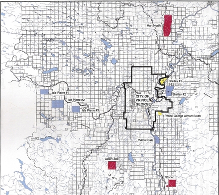
Industrial Land Study identifies lots suitable for certain types of industrial development (map courtesy Regional District of Fraser Fort George)
Prince George, B.C. – The Regional District of Fraser Fort George has completed it’s Industrial Land Profile and the Directors have accepted the study.
The profile evaluates and prioritizes the best sites for potential development. The most appropriate of the sites are to be brought up to market availability and ultimately, there would be a joint inventory of available industrial land between the City of Prince George and the surrounding Electoral areas which would be part of an on going marketing plan.
On the map above, the areas in red have been evaluated as suitable for heavy industrial, and the Hart North Region is considered “the best all round industrial site in the Prince George area.”
In making that assessment, factors such as; available water, rail, highway access, power, access to natural gas, topography, impacts to air quality, environmental and wildlife concerns.
The light blue “blocks” are suggested as suitable for Intermediate industrial, and the yellow areas would be suitable for light industrial.
There are several steps that must now be taken:
1. Integrated Land Management Bureau needs to take the steps necessary to place the highest priority site(s)on the market before acquisitions can be considered by serious investors.
2. The sites need to have enhanced information developed in the areas of potential emissions dispersions,geotechnical soils analysis, as well as rail line extension and electricity serviceability. All of these topics aresubject of a funding application to the Western Economic Diversification Mountain Pine Beetle program towhich an approval is hopefully forthcoming shortly.
3. Review, consultation and discussion with the public on the sites identified in the Profile for potential industrialuse.
4. Development of a joint industrial land inventory between the City of Prince George and the Regional District toprovide a seamless database for potential investors.
The complete study can viewed here. (It is a large file, so it may take some time to download)
Previous Story -
Next Story
Posted on Friday, June 20, 2008 03:59 AM in
News by
250 News


In my dads day there was sawmills like Upper Fraser all over the Prince George area. Now we are going back to that model. And as fuel gets more rare and expensive people will move closer to their jobs again. Leave PG to the thugs and elite to squabble over.