Flood Report
By 250 News
Monday, July 07, 2008 09:12 PM
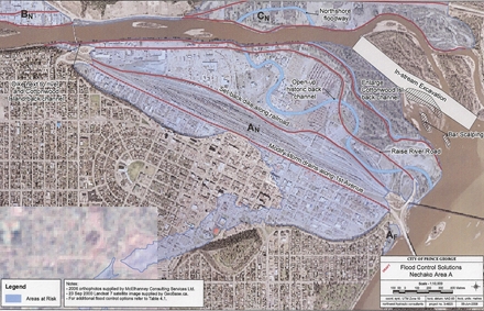
Flood control options, click on map to access full report
Prince George, B.C. – The progress report on the flood risk evaluation and flood control solutions calls for several possible actions to handle the risk of flooding on the Nechako and Fraser rivers.
The progress report says public consultation should start now, rather than when the final phase one report is due this fall. The first meeting has been set for July 16th.
One of the findings of the report is that flood risk in the vicinity of Prince George is “the result of development on areas which are subject to long standing flood hazard. This risk may have been increased by infilling secondary channels or flood plain areas, channel changes resulting from river regulation and possibly sediment deposition due to river regulation, flood history and possible affects relating to climate change in the upstream watersheds.” Monica Mannerstromm of Northwest Hydraulic Consultants says manyof the channels were not totally blocked off and that is one of the reasons there is a great deal of water seepage.
It also concludes that whether the flooding is the result of an ice jam or spring freshet, ground water seepage is also an issue.
The report notes seven areas of flood risk along the Nechako, and a further seven along the Fraser River and makes suggestions for flood mitigation on each area.
All of the areas have dyking along the river as a mitigating option and some suggest that key roads be raised. The raising of River Road to the 200 year flood level is one of the recommendations. Bill Cheung with McElhaney Engineering contributed to the report and says the current height of River Road is about .6 of a metre higher than the current flood construction level.
-River/ setback dikes • Gravel extraction • Side-channels/ floodways • Land use changes • Bylaw amendments
•
Flood-proofing • Upstream diversion or regulation • Improved drainage
Dredging the Nechako is not seen as having any benefit during the spring freshet, but further studies may find some value for prevention of ice jams “During freshet flooding, the flood levels in the Nechako River are strongly influenced by Fraser River backwater. Under these conditions, lowering the Nechako bed levels by dredging would not help reduce flood levels in the 5 km reach upstream of the confluence. The effects of dredging on ice jam related flooding will be evaluated in detail as part of the technical feasibility assessment.” Monica Mannerstromm says there is a potential that gravel extraction could help reduce erosion, but further work would need to be done.
The report suggests the work is far from over, and there is much more to be done that wasn’t part of the proposal:
“This work includes additional land and river surveys, two dimensional hydraulic modelling, sediment source and sediment transport analysis, additional sampling for white sturgeon habitat and more extensive public consultation”.
The flood plain mapping will be the last stage of the project and will not likely take place until late 2009.
City Engineer Dave Dyer says some of the land use issues may be identified sooner rather than later, and that changing the land uses may be a real feasible option "But you can never build anything that is 100% risk free' says Dyer, "Land use change is certainly something we could look into over the coming months for sure." Those land use changes could involve the purchasing of existing properties.
The price tag for the additional work is not yet known.
There were three action items on this report:
1. That Council receive the report
2. That Fraser Basin Council proceed with the public consultation process as detailed in this report; the first meeting is set for July 16th.
3. That River Road be constructed to the 200-year flood level to provide access for emergency operations, for advancing flood protection measures and for maintaining vehicular traffic through the flood plain during flood events;
That , says Development Services General Manager Bob Radloff, means the "berm will be lowered by about .6 of a metre", the access ramps would be widened, the road would be made to City standards and paved to City Standards.
Radloff says there is about $830 thousand dollars available and while he says paving the road this construction is "do-able" he would have to check with the engineers to see if the resources are available. Also, what is the 200 year flood plain? That level is the current Flood Construction Level, which is about .6 a metre lower than the current berm height and has been in effect since 1997. Councilor Don Zurowski asked if the flood plain level would be changed, City Engineer Dave Dyer says "possibly, likely, but we don't have that information at this time."
Councilor Sethen asked if perhaps the City should wait until the flood plain mapping is final so possible changes to River Road won't have to be made after it is paved. She also asked that the concerns of the businesses impacted by the changes to River Road be addressed.
4. That staff proceed with applications for grant under the Emergency Management BC 2008/2009 Flood Protection Program.
Councilor Murry Krause asked that applications for dredging be submitted now knowing that the application process is lengthy, and the window of opportunity to do the job is narrow. Monica Mannerstromm says typically, applications have to show the benefits, and says an application that is ill prepared could be detrimental to the case. "It may be better to carefully prepare it" once the full picture is available from the technical assessments and that won't be likely until October.
Previous Story -
Next Story
Posted on Monday, July 07, 2008 09:12 PM in
News by
250 News


It does say it may have an effect on ice jam flooding. Darn tootin it would.
Am I to believe that we may get some gravel removal, that they may actually be seeing the light, smelling the bacon or the coffee as they say?
I'll believe when I see it.
Radloff says..." the road would be made to City standards and paved to City Standards."
Please dont do that sir, we don't need another road in town that has more potholes
than the surface of the moon.
Maybe try building and paving to some other cities standards.