Rainfall Warning Predicts up to 50 mm of More Rain
Wednesday, June 6, 2012 @ 9:21 AM
 Prince George, B.C.- The heavy rainfall warning remains in effect for Prince George and much of the interior.
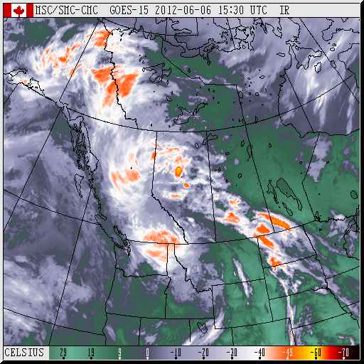
Environment Canada is predicting another 25-50 mm of rain could fall in the region today and tonight. ( at right, Environment Canada infrared image of storm)
The rain is a result of a slow moving northward low pressure system over Southern Alberta. The rain will taper off tonight as the low moves further north and weakens.
There is no change in the Flood watch which was issued yesterday for the Fraser River through Prince George.
The heavy rainfall has pushed the prediction for flooding of the Fraser River at South Fort George to possibly Friday with the Fraser expected to climb to 9.517 meters and continue to rise to about 9.944 meters Saturday. A revised forecast will be issued by the river Forecast Centre later today.
Prince George City Hall continues to monitor the situation, saying sand bags are being made available for the few homes most likely to be effected by the rising waters. The emergency operations centre remains at level one, which is a “monitoring” stage. The Regional District of Fraser Fort George has also activated its emergency operations centre at level one.
Comments
12 21 2012 is starting early!!!!!
Wish we had a dyke :)
interceptor: Not unless it ran from the Foothills bridge to down past the sewage treament plant on Lansdowne Rd. Even then, something drastic would have to be done undergound as well, to prevent seepage through the soil.
Good thing this isn’t like some parts of the world where it can dump 150mm in an hour! I saw that recently.
They have been predicting heavy rain for 2 days now here in the Okanagan and so far NOTHING!
Just a sprinkle…
some people must not be able to see the sarcasm icon.
Welcome to summer in PG.
Carbon tax is working, look at Alberta and Saskatchewan weather and they don’t pay it.
I am looking at the weather overlay on google earth and there is radar of rain right across the country with large patches patches over PG and eastward, right across the southern interior east of hope into Alberta, across the mid section of Alberta down toward the 49th parallel at Saskatchewan and Manitoba … and then further into the east.
So far, at the airport, we have received 0.3mm of rain yesterday and 12mm today.
We also received 2mm on June 1 …..
So the rain might be in the hills and coming down the mountains into the river ….
I see the potholes are full of water…. stuck with no place to go ….
Gus,
Your weather map must be inverted, normally all the rain and clouds are to the west of Hope.
Nope … not inverted … it is what it is … :-)
As a junior meteorologist weather geek this is my favourite view. Big system pushing from the Pacific another squeezing from Alberta and our weather is coming up from the South. Very strange, I don’t recall seeing this before
http://www.weatheroffice.gc.ca/satellite/animateweb_e.html?imagetype=satellite&imagename=goes_wcan_visible_m_………………jpg&nbimages=1&clf=1
Don’t forget to press “play” lol
interceptor
remember 12-21-2012
“I don’t recall seeing this before”
I think I have heard that line in a few disaster movies before :-)
Global warming at its best. Dry and desert like conditions.
Rain warnings, wind warnings, snow warnings: they all rank right up there with the Y2K and HINI flu stories. A media circus. According to the Vancouver news at 6 Prince George was afloat with heavy rain and rivers overflowing. Slow news day down south. By the way the definition of a blizzard is more than 5 flakes of snow per minute being whipped about by a 10 km gale. We have become a bunch of whimps by listening to the weather media. I remember when………….
Comments for this article are closed.