Picture Emerges of Damage from High Levels on Nechako River
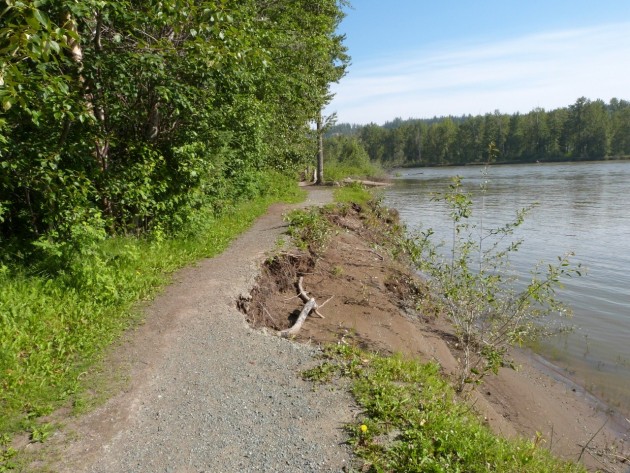
Trail in park eaten away by high water levels – photo-250News
Prince George, B.C.- As the Nechako River recedes, the true impact of the unusually high water levels is being revealed.
Cottonwood Island Park has sustained much damage.
Experts have long advised that people stay away from the banks of rivers that are high and fast as there was no telling what was happening to the bank below the water level. 250News has already reported on the loss of trees as the ground was washed away from their root structure.
Now that the water levels have dropped, the impact of bank erosion is evident.
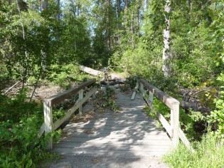
Trails have been eaten away, more trees down, and bridges damaged.
( at right, bridge will need repair from damage by downed tree)
City Parks staff will wait until it is safe before heading into the park to assess the damage and put a cost estimate on the necessary repairs.
In the meantime, residents are advised to avoid the area until the signs are removed by City crews.


Comments
“Experts have long advised that people stay away from the banks of rivers that are high and fast as there was no telling what was happening to the bank below the water level.”
I am not sure much expertise is required. Almost anyone who has lived near rivers which have strong currents and have significant floods seasonally can observe such action.
Hopefully the City will abandon this trail and move further inland with a new elevated trail and provide some clearing of underbrush so that people can access the water when the flood waters retreat in the summer, fall and winter. We do not need to spend money every year to maintain such trail locations.
As for trees, I do not know whether the City does annual maintenance checks for danger trees which might fall on people and structures during a windstorm. If this is like the road maintenance philosophy of past decades, then they may not. It might be better to prevent damage and reduce downtime for the enjoyment of the park.
“Oh the humanity!” One bridge that is actually part of the old river’s edge trail system, that can be bypassed by the existing, high and dry inland trails. The rest of the park suffered almost NO ill effects from being submerged. I run the park, through all the flooded areas as well, almost daily and many other people have been enjoying a majority of the park during the entire high water mark as well. Forget building a manicured elevated trail system that is simply a waste of money for those that only want to walk a few hundred meters, anyways.
We will likely see the embankment filled with Rip rap and the trails protected, which is far better. The fish are not spawning when the river is high.
The trail is almost always like that. Maybe one day there will be enough money to make a concert wall all the way around
or dump some rocks along the way to help stop the erosion
All this would be reduced if there was a ban on power boats during periods of high water. The waves from the boats have a large effect where ever they travel.
Maybe Rio Tinto Alcan can help with the erosion. ….All the way from Fort Fraser through Vanderhoof to Prince George.
Re-name the river.
Far to many ideas. Hire a consultant.
Don’t they need to keep the water level behind the damn to a certain level to keep it from potentially bursting! Now that might cause real damage to many places.
“make a concert wall all the way around”, thought them walls was fulla holes!
Just kidding, ain’t no grammar cop.
How bout we just live with nature, people have made their own trails since time began and we’ll continue doing it. High water’s never affected my walk through there either.
“ban on power boats”
Yeah, that would maintain the B.C. tradition;
Ban or restrict an activity to punish all participants for the actions of a few retards.
Its a wide river, you don’t need to create enough wake to affect the shores. I have observed this many times. I stick to the middle of the river and watch my speed. The wake dissipates long before it reaches either shore.
If the City wants to preserve some of the trails along the shore, they will need to put down rip rap.
metalman.
The loss of the riverbank is actually very dramatic. Some areas look like they’ve gone back nearly 20 feet or more in the past decade. Google “PG Map” on the City website and look at the old aerial images compared to the recent ones taken. In another 50 years most of that area won’t even be there. Pretty crappy considering it’s one of the ‘Top Things to Do’ in the City of Prince George via TripAdvisor.
I have been running this park since the 80’s… and it has NEVER been this developed with wheelchair accessible paths and a Cadillac version of a bridge by the train museum. The amount spent on this park and how well it rides out the high water is a testament to the due diligence some people have spent ensuring that it is utilized by many for years to come. It is a gem, within the city; you just need to roll off the couch and enjoy it.
Comments for this article are closed.