Google Trekker Coming to Northern B.C.
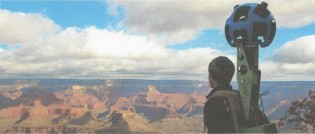
Prince George, B.C. – Northern B.C. Tourism will have an opportunity to have some of the region’s beautiful back country on Google’s ‘Trek Page’. (at right, ‘Trekker’ equipment – image courtesy Google and Northern B.C. Tourism)
The Google Trekker, a piece of equipment that is portable, but can take the same kind of images already available on Google Earth’s ‘street view’, will be used in June, July and August of next year, opening the window for ‘virtual visitors’ to see sights they normally may not be able to access.
Northern B.C. Tourism Executive Director, Clint Fraser, says “They ( Google) take applications into their program, which is a fairly new program and they look to different destination organizations and marketing entities to generate the content they need.” Northern B.C. Tourism submitted an application, and it was accepted which is pretty impressive considering some of the other destinations already available on Google’s ‘Trek Page’ include the pyramids of Giza , Venice and the Galapagos Islands.
The “Google Trekker” can be mounted in a back pack style, and can be taken to many areas not accessible by roads. ” I think it’s really an opportunity for a place like Northern British Columbia to really capture our greatest tourism asset which is our vast wilderness and landscapes and share them virtually with the world. It’s an important program to us because we know that travellers are much more technologically savvy when planning a vacation and they look deeper into the potential destinations that they’re interested in before they make decisions and this tool will really provide user the ability to experience some of our back country and wilderness virtually and help influence their decisions to come to Northern B.C.”
The Northern BC Tourism team will be trained on how to use the ‘Trekker’ then will have the equipment for a full three months ” Three months is a pretty decent duration to get out into the back country and capture some really good content” says Fraser.
Google supplies the equipment, and then it’s up to Northern BC Tourism to head out and capture the images. Fraser says they haven’t yet decided on which areas will be featured “Over the next couple of months that’s sort of what our task will be, to really lay out the plan, but we are really looking forward to building this plan into something substantial, so we’re really excited about the opportunities with it for sure.”


Comments
Bowron Lakes, Beaver Glacier, Canoeing the Nechako, Paderney Trails and view points, mountain bike trails in Burns Lake, Salmon fishing on the Kispox River, Hiking along the Pine Pass, boating in Atlin, hot spring in Nisga, moss forest in Haidi Gwaii, Hudson Bay Mountain, hiking Mount Robson and the Ancient Forest, Kakwa Provincial Park, Todd River, and Blizzard Lake, and Spatsizi Plateau Provincial Park would all be great candidates… but next to impossible to get it all.
Damn lucky the guy that gets to film it all and bring it to the world of Google Earth.
Looks very awkward. Hopefully much of it is made of plastic.
They should make sure they get into North Africa before ISIS does so that they could record places before they are destroyed.
Looks like some do not like Eagleone’s list.
Fang Mountain! Hopefully they can do a Jet boat tour from Miworth to the Fraser and up towards College Heights. It would be neat to see PG from that perspective (For those of us that cannot get onto the river).
I think they will need more than one person to get this all done, but I will agree that they will be some very lucky people to see all this wonderful scenery we have and make it available for the world to see.
Comments for this article are closed.