Gustafsen Fire Doubles in Size
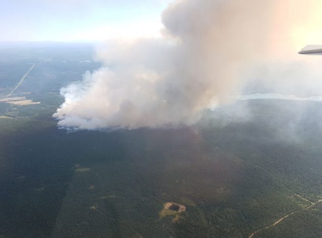
Gustafsen wildfire – photo courtesy BC Wildfire Service
100 Miles House, B.C. – The Gustafson wildfire just west of 100 Miles House has more than doubled in size from 1,500 hectares yesterday to 3,200 today.
The BC Wildfire Service confirmed the news on its website at 3 this afternoon (though it notes mapping the exact size has been difficult due to the smokey conditions).
“The fire is expected to grow substantially in the next hours and the amount is dependent on the weather and wind conditions,” it says. “The fire continues to grow but calmer winds today are assisting efforts.”
The fire remains zero per contained while the cause remains under investigation.
The blaze has already forced the evacuation of over 2,000 property owners in Lac La Hache, 108 Mile and 105 Mile.
Smokey conditions have prompted officials to urge residents to head up to Prince George of the Lower Mainland if wanting to leave the area.
There are four other fires of note in the Cariboo Fire Centre including:
– A 1,000 hectare fire north of Williams Lake Airport. It started yesterday and has forced the evacuation of the Wildwood area. It is zero per cent contained. The cause is under investigation.
– A 2,000 hectare fire 1 kilometer north of Chief William (150 Mile House). The fire (zero per cent contained) has prompted an evacuation order in the area. The cause is under investigation.
– A 100 hectare fire near Spokin Lake 20 kilometers east of Williams Lake. It’s also zero per cent contained and has forced the evacuation of the Miocene area. The cause is under investigation.
– A 500 hectare fire at Dragon Mountain about 25 kilometers southeast of Quesnel. The fire is zero per cent contained and the cause us under investigation.
The fires have also closed portions of Highway 97 including from Cache Creek to Clinton.
Check Drive BC for the latest updates.
Comments
Thank you for posting regular updates. It has been very difficult to track down decent updates. They’re scattered all over the provincial sites, Twitter, and Facebook.
Here’s the latest comprehensive update from the BC government: https://m.soundcloud.com/bcgov/wildfire-update-july-08-2017?WT.cg_n=HootSuite
Other useful links:
-Active fires map (BC gov): http://openmaps.gov.bc.ca/kml/wildfire/map.html
-Current evacuation orders (BC gov): http://www.emergencyinfobc.gov.bc.ca
-DriveBC map showing current road closures: http://www.drivebc.ca/mobile/events/index.html
-Fires by district (BC gov): http://www2.gov.bc.ca/gov/content/safety/wildfire-status/wildfire-situation
-Current fire weather maps (BC gov): http://www2.gov.bc.ca/gov/content/safety/wildfire-status/fire-danger/fire-weather/weather-maps
Comments for this article are closed.