


Grant For Further Study on Dredging Nechako Denied
By 250 News
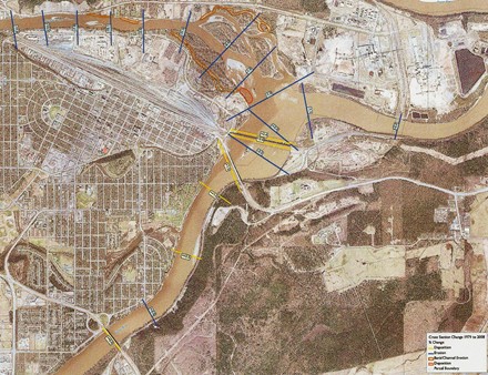
Blue lines show cross sections sites, yellow shows sites of sedimentation, while orange shows erosion
Prince George, B.C.- The details on the two grants received by the City from the Province for flood mitigation have been delivered. In his report to Council, City Engineer Dave Dyer says the City submitted three applications and the rseearch so far indicates dredging the Nechako would only have impact in two areas. $150,000 approved for Funding for the Flood Risk Evaluation and Flood Control Solutions study project
Project 2 $1,730,500 (multi-year total),denied Engineer Dave Dyer says "we continue to pursue options to advance that portion of the work, with EMBC" ( Emergency Measures B.C.) Project 3 $2 million approved for a a multi-year project to construct a dike between River Road and the Nechako River to the 200 year flood construction level with first year funding to proceed with engineering design,floodway restoration (which includes asset removal and property acquisition where property owners are in concurrence). $17,230,546 (multi-year total) was requested. Overview of Project #2 First Steps : River Road Subdrain and Pump Chamber System Given the rapid rise of the groundwater table experienced during the ice jam flooding of last winter,the installation of a subdrain and groundwater pump chamber system combined with a groundwater cutoff either beside or under a future offset dike would assist in relieving flood damage during ice-jam flooding and freshet flooding. With EMBC funding it is our objective to install a subdrain and pump chamber system within the next six months. The subdrain and pump chamber must be considered as the first phase of a complete flood protection system. Funding opportunities from the provincial and federal governments will continue to be pursued for subsequent phases of the flood protection system. There are several advantages to proceeding with this work at this time: •The subdrain would be designed to accommodate both groundwater flow and surface water runoff. During a flood event, as the groundwater rises, the subdrain would collect the groundwater that would be pumped out through pump chambers and into the river. When the groundwater is well below the subdrain, storm water and snow melt runoff would be collected from the industrial lands on the south side of River Road and infiltrated into the ground through the subdrain. •The subdrain would be a perforated pipe imbedded in drain rock to allow it to operate by taking in groundwater during a flood event (high groundwater) or by discharging surface water into the ground (periods of low groundwater). •Pump chambers/storm manholes would be installed at seven or more locations along River Road to facilitate pumping operations during a flood event and to collect surface water during non-flood periods. The subdrains would be connected to the chambers as would culverts installed underneath River Road that would collect storm water runoff from ditches on the south side of River Road. A discharge pipe from the chambers to the river would be installed to allow excess storm water that does not infiltrate into the ground to be directed to the river; the discharge pipe would have a one-way check valve to ensure that river water does not back up the pipe during a flood event. •A cut-off trench may be installed as part of the subdrain installation or during the construction of a future setback dike between River Road and the Nechako River. The cut-off trench would consist of a fine-grained clay soil or possibly sheet pilings, with the purpose of impeding groundwater flow from the direction of the river during flood events. •The subdrain can be designed and constructed within the time frame though it will be weather dependent. Normally (the fall of 2007 was the exception) the groundwater is low in the fall and winter, which makes construction feasible during this time period. •Construction materials are readily available with no delays expected for the delivery of materials such as piping. •The construction of a future setback dike along River Road would complement this subdrain project. During a flood event the groundwater pumped from the subdrain would be discharged over the dike. •If a flood occurs prior to the completion of a future setback dike, temporary gabion dikes could be installed on the river side of the subdrain during a flood response effort. •The construction of the subdrain system to also accommodate surface water, will effectively free up capital that would otherwise be used to install a storm sewer for the re-construction of River Road. The capital savings could be used for the removal of assets and property acquisition to make way for the offset dike and establishing a floodway between the dike and river. • An estimated cost of the River Road subdrain is $2,000,000 River Sedimentation/Erosion Analysis Our consulting team has been tasked with assessing the Nechako and Fraser Rivers with a view to determining: 1. The state of sedimentation and erosion in the channels. This to determine where accumulations of sediments (deposition) may pose a barrier to water flow and the extent of the deposition and in so doing determining where dredging efforts may be best applied. 2. The state of erosion on banks and flood ways so flood erosion protection works can be better evaluated. 3. Flow regimes for the Nechako river that may influence future events on the river. To undertake this component of the work our consultants have cross sectioned the Nechako and Fraser Rivers and compared current cross sections with those of 1996 (the last time sections were taken). In addition they have reviewed historic air photos and compared these to current conditions. The resultsof river cross sections are presented in the erosion deposition mapping. This map shows cross section lines in blue for sections where net erosion has occurred over the last 12 years, and yellowwhere net deposition has occurred. The value of this erosion deposition is also shown. The resultsindicate that from the Cameron St Bridge to the confluence with the Fraser, net erosion is occurring. In fact many sections exhibit significant erosion. Essentially this means that in this section of the river the bed is being widened or depended by the river. Results for the Fraser are mixed, however, it is noted that deposition is generally minor. Some minor deposition is recorded above the Cameron St Bridge as well. Based on these findings the consultant team indicates that dredging in the Nechako and Fraser Rivers will have no benefit for flood protection, with two exceptions. 1. The sectioning of the river shows that the Nechako River has re-established two backwater flow channels that it used for flood relief when the most recent ice jam flood event occurred. It is recommended that these 2 backwater relief channels be augmented and improved to assure that they function in a similar manner in future events and the sediments deposited at their outlets be removed. It is felt this is where dredging efforts could prove useful and can be achieved in conjunction with certain fisheries value improvements in the backwater channels. The results also show that significant bank erosion is occurring on the north bank of the Nechako River. This erosion is anticipated to increase in subsequent yearly cycles and serves as a risk to properties in and downstream of this area.
$255,000 (first year) denied, A multi-year gravel removal program at the Nechako and Fraser River confluence with the first year funding to proceed with the necessary 2D river hydraulic engineering, sediment transport analysis, environmental impact analyses, and regulatory agency permit applications.
Here is his report:
Project 1
Previous Story - Next Story
Return to Home


metalman.