


About 100 Fires in Cariboo Region
By 250 News
Wednesday, August 04, 2010 03:21 PM
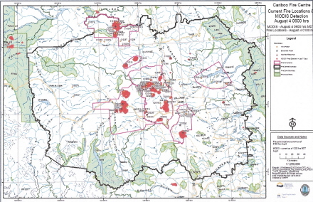
Williams Lake, B.C. - There are approximately 100 active fires burning within the Cariboo Fire Centre’s boundaries. To manage these fires effectively, they have been divided into complexes. These complexes are made up of several fires which have been assigned to a specialized Incident Management Team. This group of specialists will be dedicated to the complexes, constantly assessing the situations.
Meldrum Complex
There are a few fires of note that cover a combined area of 15,000 hectares, or 150 square kilometres.
South of Meldrum Creek
The fire south of Meldrum Creek grew to the west last night. This fire has not crossed the river, or Highway 20. A second fire within the complex, 2-3 kilometres to the west of the Fraser River, has spread down the east side. These two fires remain the crew’s priority for today.
Bull Complex
The largest fire, west of Alexis Creek, is 7,800 hectares, or 78 square kilometres in size. Crews will continue to work north of Hwy 20 on the east and west flanks of this fire. The fires have been growing in a south-easterly direction. .
Place Complex
The fire at Dog Creek, 40 kilometres west of 100 Mile, is 6,500 hectares in size, or 65 square kilometres, and is 20 per cent contained. Smoke in the area is posing a challenge today. Priority areas are the east flanks of the fire.
Pelican Complex
There are multiple fires burning near Pelican Lake, 25 kilometres north of Nazko. The fires have been very active, which has not allowed crews to obtain an accurate size update.
All of the Cariboo Fire Centre’s available resources are currently working in the region, including structural protection crews, firefighters, helicopters and heavy equipment, with additional assistance from other parts of the province and out of province.
Previous Story - Next Story
Return to Home