Clear Full Forecast

Cottonwood Island Park Closed

By Michelle Cyr-Whiting

Wednesday, May 09, 2007 10:05 AM

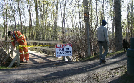
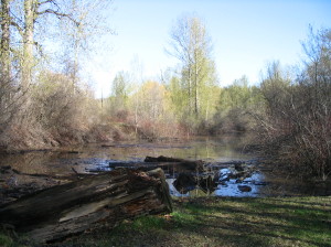
High water levels have covered some of the park’s inner trails

Cottonwood Island Park is closed to city residents...

City worker Kevin Miller is closing down the foot bridges leading into the park’s riverfront trails as high water forces the closure.

Miller says the level of the Nechako River rose considerably overnight prompting this morning’s closure.

The Heritage River Trail from the Cameron Street Bridge to the Yellowhead Bridge has also been closed until further notice.

The City plans to issue a public advisory when the trails are re-opened.


Previous Story - Next Story


Return to Home
NetBistro

Comments

These river side parks flood each and every year so this is noting new. Are we in for a big one? anyones guess is as good as mine.
I see that there was no dike money from the BC Government so am I to presume that Bell, Bond and Rustad have homes well above flood levels?
I don't hear much from them trying to get help!
As stated above every year we lose more trails to the river and parts of them are so undercut that they probably aren't safe..yet nothing is done to stop the erosion.It will be Cottonwood Island Drive soon as the park will disappear!!
The City applied for money from the BC Government to raise River Road by 4ft from I beleive Brink Forest Products to Maybe the Pas Lumber Co., The Provincial Money was available for projects that would be substaintially completed by May 15th.

The City applied for this money to late, had a lame brain plan (The flooding is usually further East than the Pas Lumber) and didnt have a hope in Hell of getting it comleted on time.

As usual as soon as this City heard money was available they came up with a hair brained idea to get some and spend it. (Whats new)

It seems that once the Provincial Money was not available the City decided that there was no threat, as I dont see them doing anything in that area on their own. There is nothing stopping the City or the Citizens of Prince George taking some action on their own. It will be interesting to see if they do, or if they will just issue advisories and watch the water rise.

How high is the water Mama. It four feet high and rising.
The idea to raise River Road is ludicrous to me. What should be raised is a path going along the waterfront at some reasonable point which would protect most of the park, at least tjose parts of teh park which have "improvements" in them which can erode with continuous spring floods. As I have posted several times prviously, why do we have to get a lesser system than the communities along the Fraser delta have? Most areas there are protected by dikes and they are typically close to the riverbank. The railway and forestry museum yard, for instance, is not protected. Only the new building is.
There is now water at the East End of 3rd and 4th Avenue and the City has closed off some of the approaches. This water comes up from underground. Water will also start servicing in other areas as the Nechako and Fraser continue to rise. Dont be surprised to see water is Carrie Jane Park.

I see City personel working on the pump at the East end of 1st Avenue.