Clear Full Forecast

Industry Group Pushes for Permanent Dikes

By 250 News

Friday, January 04, 2008 04:02 AM

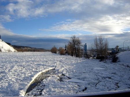
The ice jam , looking east from the Cameron Street Bridge.  (Photo courtesy  City of Prince George)

Prince George, B.C. –  As the ice jam on the Nechako  River  expands and contracts, the Nechako River Industry Group has set a goal of having  permanent dikes in place on  both sides of the Nechako River by  October 31st of this year.  

The goal is an ambitious one, but one that is crucial to Prince George says NRIG Co-Chair John Brink “We are now identified as a national corridor between Asia and the United  States, we cannot have a transportation corridor that is not available year round. We cannot succeed  as a transportation corridor if we do not have a guarantee of reliability.”  The group already knows they face the risk of flooding now through March,  and then there will be the freshet which will cause  a whole new set of concerns.

Brink says the  group  has a current membership  of  about 50 businesses, but  expects it to  grow to  300 to  400 “If you look at downtown,  virtually everything east of Victoria Street is in the 200 year flood plain,  all of Prince George  is a stakeholder in  this”.

The group is hoping to attend the first City Council meeting of the year to introduce themselves and to outline their goals.   The group wants to work with the City and with all stakeholders.  Brink says there is funding available for diking   “We have flows that are two and three times the norm because of the devastation by the mountain pine beetle, there is funding through Natural Resources, there is infrastructure funding available.”

Brink believes there is reason to believe the Provincial and Federal Government will act quickly “This is a crisis, and in a crisis everything is possible. If there are people who are standing in the way, they must be moved out of the way so this can move forward.  We need to ensure the Nechako River stays within its banks 24-7, 365 days a year, there is no time to waste.”

Monday night,  Development Services is expected to  present its  long term flood mitigation plan. That multi million dollar plan includes raising River Road.

    
Previous Story - Next Story


Return to Home
NetBistro

Comments

Its good to see John Brink taking the lead on this. I wish him the best of luck and hope he is sucessful.

I would like to add that it would be nice if a new dike could be incorporated into a river front trail system for duel purpose use.
Walk on top of the dike.
Better that industry should move out of the bowl and find a new home.
I agree with Foo738.........let's move
all of PG to HIGHER ground...dahhh
Diking is a short term solution and unless you dredge the river your wasting your time.
I've said publicly many times, and I believe on this blog, too, that River Road should be a dike.

Usually the context was to call bullsh*t on the concept of a 100 year flood plain, and all the reasons you "can't" develop on it (can't develop downtown).

Usually I would say "I'm from Winnipeg; don't tell me about floods."

Now, I find it interesting that for years and years and years our city councillors have been unable to figure out that proper diking and dredging is an elegant solution.

But it seems smart, standard practices from other jurisdictions rarely make their way to our council chamber.

It's a shame, but you know we're going to elect the same bunch this November.

Shame on us.
This is the typical knee jerk reaction. Build a dike.

A solution is being promoted by people whose industries are being threatened not only by MPB, the rise of the C$ against the $US, location in the centre of a city growing around them and “landlocking” them, a bridge that was not maintained properly, and now the realization that they too, just like those many residences in the Cottonwood Island Park area before them, are impacted by flooding, perhaps in a more serious and frequent way in the future due to climate change.

Before one seeks solutions, prudent people find out first what the problem is and what the many causes of that problem are. Once they know what the problem is, one looks around to see whether others have similar problems, what the solutions are/were when they were faced with that problem, and then adopt or adapt a system … and in rare cases, develop a unique solution.

So, the problem is flooding, including flooding due to ice jams. What we really do not have a good handle on is what the causes are – damming the river; poor water release control; insufficient bank protection downriver; build up of sediment; increased natural water flows due to MPB and climate change; building in the wrong place; lack of safety channels; no upstream control of ice movement; lack of monitoring systems; lack of early intervention systems based on river monitoring; lack of local knowledge about today’s control and mitigation approaches; and so on.

In a nutshell, only after assessing the problem, setting goals and objectives, and reviewing all reasonable solutions possible can one begin to select the most appropriate mitigation measures for a particular community

Here is a bit of a scan of the situation we have and have had.

The Nechako River is a controlled River in that the Kenney Dam has caused the water flow in the upper arms to be reversed. Thus, the total volume flowing down the Nechako has decreased, but the periods when the highest volumes of water flows have changed. Other than that, there has been virtually no downstream control of the banks. The main mitigation measures so far have been to move residents out and to begin, in portions, a land fill project to raise the level of the land above the 200 year flood plain. In addition, I believe Pulpmill Road on the north side has been built above that flood plane as well, in effect, creating a dike. The portion of that road at the Hart Highway bridge end was raised during the twinning of the bridge.

We are located at the headwaters of the Nechako. So, one can look at other headwater areas. In addition, we are sitting on the Fraser, which may present its own problems for us.

The Richmond/Delta area of the GVRD is greatly diked to protect it from the sea was well as from the variable flows of the Fraser. They are beginning to look at how climate change will affect them. The Dutch and Germans are not only looking at a similar situation with the Rhine River which has close to the same watershed size as the Fraser, they have a plan in place of how to protect lands better. They have dams in place, but they are generally not building them higher, they are “making room for the river”. The situation has been found to be the same for the Mississippi River in the US. Rather than fighting with nature and hemming rivers in as has been done in the past, reduce water levels along the way by widening the river bed to accommodate high water levels.

Here are some measures which should be considered to be applied not only in Prince George, but all the way along the river from the spillway.
• Review the control of the amount and timing of water releases to see what, if any, improvements can be made to mitigate the effects on the Nechako flow at critical times of the year.
• In the Rhine system, where it can be done without harming healthy ecosystems, foreshore areas between the river and dikes are being excavated to lower their level and leave more room to hold floodwater.
• In the Rhine system, a dozen dikes are being moved further away from the river, again to give the Rhine room to flood; some homes and buildings will be torn down to accommodate the realignment.
• In the Rhine system, land along an upstream reach of the Dutch portion of the river is being set aside as a "last-resort retention area" that will be flooded in extreme high-water emergencies.

The Rhine
http://www.ruimtevoorderivier.nl/files/Files/brochures/EMAB%20PBK%20Engels.pdf

The Fraser
http://www.infolynk.ca/bcfishing/FloodMitigationML-April06.pdf

We have the opportunity to do this thing properly rather than half assed. It speaks of stakeholders. Well, that includes the rest of the population of this city and it includes DFO and MoE and the City’s planning department that needs to take long range plans in the city ionto consideration so thst good money is not thrown at something which will be abandoned by industry within the next 5 to 10 years. While this gorup is well meaning, it is acting primarily on self interest not community interest. We have an opportunity to make major change here rather than battening down the hatches and preparing for the past after the fact. Let us prepare for the future with forward thinkers.
I forgot to mention that diking alone will not solve the problems of the residents on the north side of Pulpmill Road who find that they are not being hit by water moving accross Pulp mill road, but by water percolating up through the porous soil. That may also be a problem with the area at the east end of the Queensway east light industrial area. With effectively higher levels of water in the Nechako the increase in head pressure will likely have other effects in the city, including the potential of water seeping up in the ares of the CN tracks. So, we had better do some soil investigation first, if we do not have that information. Or we have to build a mechanical assisted dewatering channel behind the dam, if that even works with the type of porous soil we may have in those regions.

Just think it through, by building the river banks higher we are assisting the water to stay in place at a higher level, with ice building itself up as high as it will take until the water finds another way around. You think they have a problem in Morning Place up river now? Wait till we assit the ice to build a higher dam without finding a path through the system by creating its own channels outside of the normal river bed.

I can see this becoming a sink hole for city/provincial dollars like we have not seen before if we do not tackle this in the right fashion .....
As Palopu said much more succinctly: "Diking is a short term solution"

As far as the "unless you dredge the river your wasting your time" part goes, I aggree that is a part of it, but likely not the only part of it.

Also, the dredging, of course, also needs to be done part way down the Fraser to ensure that the channel bottom can properly integrate with the flow of the Fraser underneath the normal sruface ice formation.
You have it pretty well covered Owl. There are a few things to be considered.

(1) The main channel for the Nechako running into the Fraser is on the North Side of the Nechako close to the North East end of the Rail Bridge to the Pulp Mills. Year ago this main channel was on the South Side and converged with the Fraser in a Southward fashion past Fort George Park. The color of the water from the two rivers was obvious> Nechako clear,Fraser muddy.

(2) Sediment build-up since the creation of the Kenny Dam has obviously created a situation that has forced a change in the natural flow of the Nechako. I suspect if you cut down one of the older trees on some of the islands just west of the confluence and counted the rings you would determine that this problem is less than 50 years in the making. So a major dredging project is in order on both the Fraser and Nechako rivers, along with the appropriate dyking. However as you stated this water perculates up from under ground so no amount of dyking will solve that problem.

(3) If you dyke the river without dredging you run the risk of huge flooding further up the river. Years ago the budget car sales on 1st and Victoria used to be a shell service station, and it flooded from the under ground every spring. I understand that the BDBC building on 2nd and Victoria has some water leakage in its basement. The East end of 2nd and 3rd avenue are prone to perculation. Carrie Jane Gray park, and Mascish Place Stadium are built on an old slough, this water still runs through that area, below Pine Street, under Queensway and into the Fraser. This is the natural flow for the water during high water, and if you back the river up far enough, that is where it will go.

(4)There is excess water running into the rivers for this time of the year due to heavier snowpack, plus MPB, however Alcan is also part of the problem. Since they closed one of thier pot lines a number of years ago and laid off 400 employees they now sell the excess power to Hydro. However the question is. Does Hydro need, and is it buying this power? If not then Alcan has to reduce their generating capacity. Last I heard Alcan had one generator down and 7 operating at 3/4 capacity, which in effect means 2 generators down. If they were operating at capacity, there would be much less water being released into the Nechako. It seems their plan is to continue to release at the present rate into late February.

We need all levels of Government to wade into this problem (Pun intended) however it seems that the general consensus is that the DFO will put a kibosh on both dyking and dredging. This will be a golden opportunity for our local politicians to show us if they have any clout.

If your ever wanted a long term project, that will create jobs, and have a final solution with benefits for both commercial, residential, and recreational, this is it. Can we deal with it, or will we go with the so-called experts and do nothing and let nature take it course.
Let's all use the word mitigate at least 10 times a day. The mayor's PR mouthpiece has made sure that it is used regularly. Let's mitigate city council, the provincial government, the federal government and all the people getting rich from this river blockage. Mitigate, mitigate and mitigate some more. I know other big words also; delicatesan, gymnasium and kindergarten. Ain't I smart?
"While this gorup is well meaning, it is acting primarily on self interest not community interest. We have an opportunity to make major change here rather than battening down the hatches and preparing for the past after the fact. Let us prepare for the future with forward thinkers"

I agree. I think Owl and Palopu have made very good points.