


Deadline Today For Dangerous Goods Survey
By 250 News
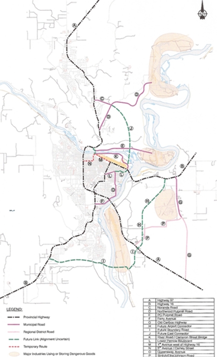
Suggested routes, for a more detailed map, click here
Prince George, B.C. – Today is the last day for participation in a survey about a dangerous goods route The consultant handling the survey (Opus –Hamilton) has received 135 surveys so far. “That’s pretty good seeing as how most people don’t like to fill out a survey” says City Traffic Engineer Glen Stanker, “but so many more voices have not been heard.”
Stanker says there are stakeholders needing to know which route will be selected and the sooner the better. “We won’t be extending this survey as that would put everything off and lots of people have been waiting for these decisions.”
Stanker says the survey is the best opportunity for the public to “get in on the ground floor” of the design of a dangerous goods route because the next step will see a draft developed. “We want to hear what people have to say about these candidate routes, we want them to give us the direction we need” says Stanker.
You can fill in the online public survey by clicking here or you can complete the survey by visiting the front desk of City Hall.
Dangerous goods are defined as corrosive, poisonous or explosive substances which may be transported by trucks. These include gasoline used at service stations, and chlorine used at swimming pools.
The public and stakeholders will be invited to provide additional input on the draft documents in May.
Previous Story - Next Story
Return to Home
What this strategy of the city does is it kills a real dangerous goods route for PG for at least a couple of generations because its not every other year that senior governments would look at building new dangerous goods routes. This route will shape this city for the next 20-years more than any other thing from forestry to the university due to the fact that industry needs to locate near these types of routes and thus it will shape whether industry locates downtown further polluting the bowl or it locates in an appropriate location.
The most important thing to remember is the only options the city is looking at is the options that are including inside the city limits, because the city feels the world does not exist outside the city limits or something. Maybe they only have city maps? The city wants the city to pay for the dangerous goods route and does not want the provincial and federal governments to pay 100% as they should if it was located outside the city limits as it should be.
The city wants to subsidize their airport industrial park hidden agenda with the infrastructure needed for that as well as their Patricia Blvd downtown dangerous goods build out. they want those projects to be funded under the umbrella of a dangerous goods route and will adjust and fudge things in the conceptual stage like the Boundry road to no bridge, and the River road connector to the McMillin Creek headwaters so as to make lines on a map fit with their real agenda. It all has nothing to do with a dangerous goods route.
They will regulate to make it look like they have done something about dangerous goods to compensate for their lack of real planning.
This report is disingenuous to this point in time and is nothing more than a political hoodwink designed to say they listened to the tax payer. In the end we will not have a real dangerous goods route, we will not have access to industrial lands outside the city air-shed, and we will still have 15 traffic lights for through traffic going through town centre. 20-years from now we will equate it with locating the pulp mills and oil refinery across the river from the downtown.
Maybe they will prove me wrong, but as it looks that is not the case with the maps they are drawing up.