Clear Full Forecast

Dangerous Goods Route Proposal Outlined to Council

By 250 News

Monday, June 23, 2008 09:19 PM

Prince George, B.C. - The  public is invited to give its input on the Dangerous Goods Route Study at an open house set for tomorrow, but City Council got a look at the initial report tonight.
 
The report presented showed maps of routes currently being used, short term routes, and a plan for a medium to long term route.
 
The consultant doing the report (Opus Hamilton)   has completed the analysis of the information gathered from the City, stakeholders, and a survey. The preliminary   information puts forth a short term and long term plan which will be presented to the public and the final report will be delivered at the end of August.
 
Consultant rep Sarah  Rocci  says one of the  items brought forth by stakeholder and public consultation was the possible use of Foothills Boulevard which was something that hadn't been previously considered.
 
The  routes were graded based on nine items, including geography, lack of sharp curves,  signalled lights,  emergency response,  evacuation  routes, and  collision  history. 
 
The Lower Partricia Boulevard  route, which had been suggested in the past, was dropped from consideration because it scored poorly on several of the  grading criteria. Queensway  also scored poorly, so in the opinion of the consultant, the lower Patricia and  Queensway connection are off the list.
 
 
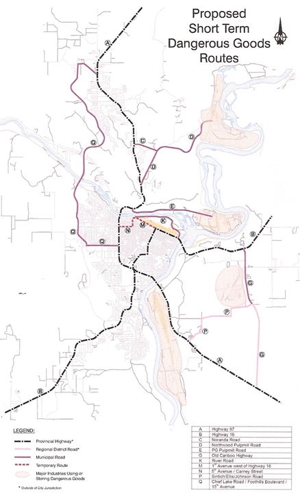
The map below is of the suggested short term routes, ( no use of Cameron Street Bridge becauseit is not  available) scroll down for the long term suggestions:


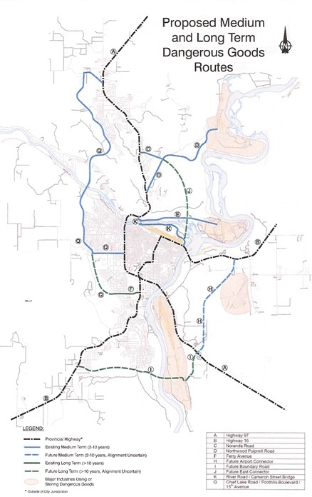
The second map, below,  is the outline for mid-to long term routes. 


The  consultant says some of the roads suggested, could use some work  to  reduce the  impact of a possible spill, or widen the turning radius to make the roads safer for dangerous goods.

Sarah Rocci   says if she had to adopt a dangerous goods route tomorrow she would adopt the short term route as outlined.  She also suggests marking the routes on Google, or map quest to ensure the routes are available to truckers.
 
There are two sessions for the Dangerous Goods Route  Open House,  from 3-5 and again from 7-9.  Both sessions will take place at the Civic Centre tomorrow.
 

Previous Story - Next Story


Return to Home
NetBistro

Comments

Using Foothills and how the traffic would come up 15th would seem a most illogical choice. During the summer months the highest concentration of population in PG can be found any night and most weekends at the soccer fields. ( Kids, men and woman's leagues ). Then turn onto Foothills and go miles and miles by Residential housing and then cross over a bridge, that if something would spill in, then would be passed through the entire city via the waterway.

I realize the layout of PG is not the easiest to accomplish a Dangerous good route but in some ways the easiest way is being selected and not the best way.
As I mentioned yesterday on here, foothills was the choice made by UNBC. It is easy to see why when one looks at an incident anywhere along the route, the route is pretty well single loaded - residential pretty wll all along the way only on one side rather than two sides in all other locations.

In addition, at most times of the day, it is a quieter street than say Central, Vctoria and Queensway plus, depending on the route, those take one on a longer path, increasing he probability of an incident.

Having said that, it is agian one of thpse situations where anyone who bouhgt a residence within one, two three streets parallel to the major highway through town, would expect traffic noise at night when everything else is quiet, some would even expect some pollution, and those who are really safety minded might have given dangerous goods some consideration.

Those in a similar geographical relationship to Foothills would, however, have felt that the road was an internal. primarily residential arterial, not a short cut between 16 west and 97 north which, in effect, it will become.

Thus, what will happen is a road that has very little risk associated with it now, will all of the sudden have its risk level raised. So, at best the risk level in one place will be reduced somewhat, while the risk level in another location will be increased.

It becomes, as so many things in today's society, a decsion made by a computerized model ...... and we all know the old addage of garbage in .. garbage out.
Good luck with the route designated 'J' in the medium / long term plan.

That one involves a crossing of the Nechako at a sensible location (near Cottonwood Island).

Now that the Kinsley Memorial POS Bridge is underway at the Cameron Street site, you can kiss any prospect of a 4-lane bridge at the confluence good-bye.

They're making great progress there, by the way. I'm sure it'll be open for traffic this fall, just like the Blue-Man says.
BTW, for anyone who saw the Council meeting on this, Scott was right on the money. He was expecting more than someone just pointing out where the routes using the existing are. As he said, that is rather obvious. He wanted to see where they should be.

The Mayor took a shot at him, saying that he has not control over provincial and federal highwys going through the city.

This is the same ignorant response he had and probably continues to have with respect to air quality and control - it is provincial jurisdiction, not municipal.

The response at the time by the provincial staff was that without the city demanding better control, they have no clout with the upper management of the ministry. If the city does not squeek, then let it be.

Sounds quite reasonable to me.

So here we are again. The Mayor of this City not acting like the head of a City should be and looking out for its citizens and pushing the province and feds to improve the highway situation in the City.

Unbelievable ...... :-(
Well said Owl. I could just laugh at this report, but whats the point. They just don't get it....

A ten year old with crayons could come up with more insight and foreword looking then this report has.

Very disappointing. Not sure if PG is really worth staying long term with the kind of people we have commissioning these kinds of reports that our enemies could have done a better job preparing for us. Where is the future going to come from in this city if we aren't prepared to pave the way for it?
Central street has a daily traffic volume of 1/3rd that of the Golden Gate Bridge. the Golden gate is going through a $10 billion dollar upgrade to move its traffic and keep there economy going.

Seriously folks a few hundred million for a proper ring road is not a lot of money for our senior governments to pay for compared to what they pay for in other places with similar or less traffic concerns to say nothing of dangerous goods.

The cost to put in underpasses if we continue to funnel all traffic through the center of town is to costly... the only option is a real plan for a ring road.

I think the mayor looks at this from a potential loss of city revenue if a real ring road enables industrial plants to locate outside the city limits and airshed. Its a selfish perspective with no foresight IMO.
even the south bi-pass road is a stupid loacation. We have no idling laws but we will plan a highway so that they have to climb the whole College Heights hill only to come down the other side and climb it all over again? Didn't they even look at a topography map? This is an operational cost of thousands of liters of diesel every single day because a consultant doesn't realize it takes fuel to move 60-ton loads up and down these hills. Either that or the consultant doesn't bother with that fact because it is not a number that will effect positively their final report in capital costs for the project they propose. Its short sighted on their part.
Looks like they're keeping 5th...how stupid! It is the busiest and has an accident of some sort there almost weekly that I personally am aware of. The mayor's comments were idiotic towards Scott. Kinsley: You are the chair of the meeting, NOT THE KING OF THE HILL!
Foothills as a dangerous goods route? What a bunch of BS. Send trucks through a 100 % residential area. This city is dumb enough to push it through anyway.

I live on Foothills and we already are getting choked on diesel from the construction trucks going by. The longer I live here the more I'm getting to hate this bloody city. Send more semi traffic behind my house and raise my taxes to boot.
Well you know they made Carney Street a dangerous goods route and it is all residential. Add to that 5th Avenue, go along Carney and you encroach on three neighbourhoods with a school in the middle. Now isn't that shortsighted? Add to that the Cameron Street bridge which just keeps hazardous goods in the area for another how many years?
No thought for the residential taxpayer. It is too late for a new Mayor this present one has just done too good a job gumming things up.
Maxwell says the longer he lives here the more I hate this bloody city. I don't hate the City but I won't be voting for one person that is presently on Council.