Clear Full Forecast

Airport Lands Plan Approved

By 250 News

Monday, October 06, 2008 10:04 PM


Prince George, B.C.- The  plan for the airport lands light industrial park has been approved by City Council.
The plan will provide the future light industrial land base for the City. “We have the opportunity to create a world class light industrial logistics park” says Heather Oland of L & M Engineering.   
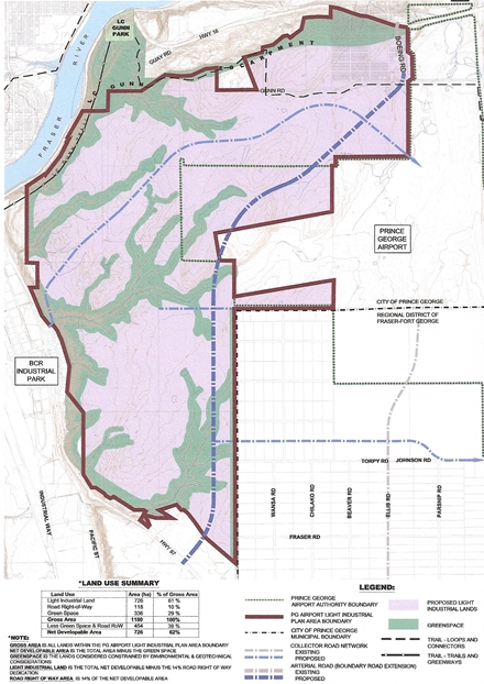
Oland says the technical report identified some steeper slopes that   may  need to be investigated further. She says 38% of the lands are permanently protected by greenbelt and open space.
The air quality report indicates there wouldn’t be any concerns about  Pm2.5  or Pm 10 and air quality would be greatly improved for the Bowl area of the city when Boundary Road is developed and heavy truck traffic is moved out of the core.
The transportation plan would include not only provide routes for   transit, and cycle routes, but pedestrian connections and greenbelt  and trail system.
The plan calls for some minor commercial operations to support the  workers in the area.
The bottom line would see 726 of the 1180 hectares developed   (62% of the gross area) .  Oland said during the public consultation process, people said the potential  for job creation and  transportation routes were positive factors for the City.

Previous Story - Next Story


Return to Home
NetBistro

Comments

On the surface this is good stuff and I'm glad that we aren't sitting back and hoping that everything just fixes itself. It's good to see us being proactive in trying to encourage new development.
I think with Pg's lower cost of living it would be a desireable place to relocate some manufacturing. I know Kelowna has a hard time finding workers that can afford to work for the wages they pay.
Greedy homebuilder's prices will rise again if this happens, so the lower cost of living concept will fly out the window.
We will be the kelowna of the north.

As for particulates, whatever a boundary road diverts from the core will be replaced by exhaust from diesel emissions from the trains on first ave, and Jet exhaust emissions from the added air traffic.

It all goes where the air flows and on a lot of days you can see pollution blowing into the downtown core from vantage points on the other side of the city.
What a hair brained plan. Why did the city permit this development in the first place? Why was it not buiilt off the Old Cariboo Highway or Johnson road? Why spend 48 million on infrastructure when not more then a kilometer away we already have a dangerous goods route or ring road, the old Cariboo highway and Johnson road.

We havent been able to manage the what has happened in the past and here we are always looking at the futre. These people think like Joes dog that died barking at the moon.

Cheers
Those slopes in there are huge massive drainage pits hundreds of meters deep. It is all sand and mud and no gravel in the ground meaning the cost to haul in the gravel to make those slopes stable and the land stable will be an insane amount of cost to the city tax payer akin only to the Universtity Way slide area.

They are looking at an $8million dollar per kilometer of road cost as an estimate, and I think it will be double that when all is said and done and the city is on the hook for all of it at this point. Thats a $100 million dollar home tax pipe dream that says nothing of the costs to also service the commercial lots to make them viable.

I think the city needs a lot more information before committing the city tax payer to this project. What where the alternative locations and why was it that they were not chosen over this location? That is an important question that comes to mind. Who made the location choice and what were the determining factors to make this choice and what was the cost analysis that gave this location the green light over existing locations, or ruling out synergy with a future ring road?
Eagleone... "Who made the location choice and what were the determining factors..." DUHH!!! I guess you havn't noticed that there is an airport up there,and it is perfectly situated for this kind of devolopement. Airport logistic projects are normally close to AIRPORTS, RAIL, GOOD TRUCKING ROUTES and AFFORDABLE LAND. We've got it all. By the way..What's "synergy " got to do with this. ("synergy" n. the working together of two or more drugs or muscles.) Had to look it up..never learned that word in grade five.
Refuelling large airplanes at the airport? Sure hope the fuel costs there won't be comparable to gas prices in this town.
Airlines really dont have a choice - Anchorage is overloaded and PG is the only alternative. If you look at Anchorage, you see the money involved is small potatoes. And this is the year 2008, there are ways of dealing with sloping land. Also, fuel prices will likely come down long term since a large airport will use lots of fuel. This would encourage oil exploration and processing in the region, like it did in Anchorage. And to those who doubted the Seattle flights to PG, note how many dailies there are between Anchorage and Seattle.

The following is from Wikipedia:
http://en.wikipedia.org/wiki/Ted_Stevens_Anchorage_International_Airport

Constructed in 1951 as Anchorage International Airport. It is Alaska Airlines' second-largest hub, after Seattle. It is also a major cargo hub and, as of 2005, ranks as the world's third-busiest airport by cargo traffic, after Memphis and Hong Kong. The majority of passenger flight operations are on Alaska Airlines to and from Seattle (an average of 20 flights per day) and Fairbanks (an average of 13 flights per day).

FedEx Express and United Parcel Service operate major hubs at Anchorage International for cargo heading to and from the Far East.[3] NWA Cargo also operates a major hub at the airport. FedEx Express is the airport's largest cargo facility and can handle as many as 13,400 packages per hour, employing more than 1,200 people and providing a full customs clearance system. United Parcel Service's hub handles about 5,000 parcels per hour. Both companies forecast a large growth in traffic over the next several years as trade with China and other Far East countries increases and plan to expand their Anchorage facilities comparatively.

Anchorage is also envisioned as a future connecting point for air traffic to the Russian Far East. There is during the summer season 2008 only one weekly flight to Russia, by Vladivostok Air. Also, there are plans to add flights to Sakhalin in the near future to meet the demands of U.S. oil companies.[4] Many of Alaska's North Slope workers live either in Anchorage or elsewhere in the Lower 48 states and fly through the airport to their jobs in Prudhoe Bay.

Ted Stevens Anchorage International Airport covers 4,500 acres (1,821 ha) and has three asphalt paved runways: 7L/25R measuring 10,600 x 150 ft (3,231 x 46 m), 7R/25L at 10,900 x 150 ft (3,322 x 46 m) and 14/32 at 11,584 x 150 ft (3,531 x 46 m).[1]

For 12-month period ending December 14, 2006, the airport had 289,472 aircraft operations, an average of 793 per day: 37% scheduled commercial, 35% general aviation, 27% air taxi and 1% military. There are 169 aircraft based at this airport: 59% multi-engine, 27% helicopters, 11% military and 3% jet aircraft.[1]

Cargo airlines

* ABX Air
* Aeroflot-Cargo
* Air Canada Cargo (operated by World Airways)
* Air China Cargo
* Air Atlanta Icelandic
* Alaska Airlines
* Alaska Central Express
* ANA & JP Express
* Asiana Cargo
* Atlas Air
* Cargo 360
* Cathay Pacific Cargo
* China Airlines Cargo
* China Cargo Airlines
* Empire Airlines
* Era Aviation
* EVA Air Cargo
* Evergreen International Airlines
* Everts Air Cargo
* FedEx Express
* Gemini Air Cargo
* JAL Cargo
* Kalitta Air
* Korean Air Cargo
* Lynden Air Cargo
* Nippon Cargo Airlines
* Northern Air Cargo
* NWA Cargo
* Polar Air Cargo
* Shanghai Airlines Cargo
* Singapore Airlines Cargo
* Southern Air
* Trans Northern
* Transmile Air Services
* Tradewinds Airlines
* UPS Airlines
* World Airways
Thanks for the post gamblor.. that should shut up the naysayers that have their head shoved up their a&&.
If this is such a sure fire project why in hell are we using tax dollars to get it off the ground? We are being fed a lot of bull by the dreamers on this project.

Cheers
Ho Hum... Some just don't get it. I guess that's why some people sign the front of a paycheck and some sign only on the back.
um... because tax dollars build all our runways and roads??? Because without the tax dollars this opportunity doesn't exist??? Because at some point Anchorage also used tax dollars to get their airport off the ground??? Connect the dots, it ain't hard...