


Flooding Hits Several Communities
By 250 News
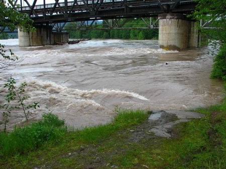
Skeena River boils under the railway bridge (submitted photo by Gordon Parfitt)
Terrace is bracing itself for a flood as the Skeena River continues to rise. As of midnight last night the Skeena had risen 4 meters since June 1st, (13 feet) at Usk, just east of that community. Sandbagging is underway and efforts are being made to pump out low lying areas.
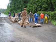
Photos below left, residents help fill and put up sandbags, while at right, water from the Skeena rushes through a yard ( photos submitted by Gordon Parfitt)
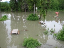
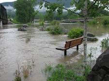
Below left, water from the Skeena and Kalum rivers floods the Fisherman’s Park at the boat launch on the Kalum River (photos submitted by Gordon Parfitt)
Further to the east at Smithers, the Bulkley has risen a further .6 meters in the past three days ( 23 inches ) Long time resident George Wall says flooding is occurring in the low lying areas in that community as well, below Chicken Creek . “There has been a lot of bank erosion” Wall says, “giant Cottonwood trees are being swept away by the high water. The par three is under water and flooding is occurring at Ebenezer Flats.”
Houston Resident Barry Goold says the Bulkley River in that community is beginning to drop and fears that it might spill its banks into that town have ended. 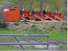
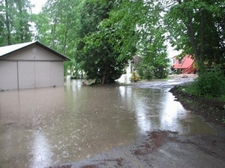
The Town of Houston had placed sandbags on all of the manhole covers, sand bags around residences, and as shown in the photo at right, CN had brought in several water pumps to move water from the subdivision where Goold lives. “The water never got much higher than it was a couple of weeks ago” says Goold, but the Morice River which flows from the mountains where the snow pack was 160% of normal, and meets the Bulkley downstream of Houston is causing problems in Smithers to the west.
To the south at Quesnel, residents say the Fraser was about the same height three weeks ago when they had a heavy rain, it dropped and now has risen back to its previous levels. While the underpass on the railway is closed, residents say this happens every year and the traffic is re routed over the railway tracks during the spring run off. Across the river the dike built to prevent water from entering West Park, that area has about 2 meters to go before it hits the bottom of the dike and residents to this date feel they are well protected.
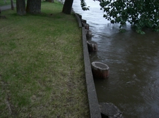 Here in Prince George , the Nechako River at Isle Pierre has risen about .07 of a meter (3 inches) in the past two days due to the large volume of water entering the river from the Nautley River west of Vanderhoof . (photo at left shows water level blow the reinforced bank behind Winton Global Office on River Road.)
The Nautley spilled over it banks some two weeks ago and has remained high due to the hot weather in the region. In Prince George, the Nechako is high as it meets the Fraser, backing up through Cottonwood Island park.
Previous Story - Next Story
Return to Home